|
|
|
|
Home If you are an experienced user, you can go directly to the viewer: Browsers | Viewer | Map | Scale | Layers/Legends | Redraw Map | Tools IntroductionWelcome to The National Map Viewer. This viewer allows you to interactively view The National Map data as a map, customize the view, and print a map. Map tools allow you to move around the map, zoom in and out, identify features, and perform other functions. In the future, advanced functions will be available.Browser Recommendations and System RequirementsBe aware of the following requirements/recommendations for this application. We strongly recommend using one of the following browsers to view this application on Windows-based computers:
Important Note: The Viewer uses pop-up windows for some data entry and to display some results. You must temporarily disable any pop-up blocker that you have installed on your machine for these windows to work. The National Map Viewer interface does not support the use of the browser "Back" and "Forward" buttons. The ViewerThe map viewer window is divided into three active areas. The map is in the center of the window. The Scale, Layers/Legend, and Redraw Map display to the right of the map, and the Tool Bar displays to the left of the map.Click an area of the viewer screenshot below to find out more. 
Map  Scale  To the right of the map is a zoom-to-scale tool, which also indicates relative scale. The bar indicating the current scale is darkened. Clicking any bar to the right of the current scale causes the map to zoom in and redraw. Clicking any bar to the left of the current scale causes the map to zoom out and redraw. To the right of the map is a zoom-to-scale tool, which also indicates relative scale. The bar indicating the current scale is darkened. Clicking any bar to the right of the current scale causes the map to zoom in and redraw. Clicking any bar to the left of the current scale causes the map to zoom out and redraw.Layers/Legend A Layers/Legend selector shows below the Scale tool. Clicking on the Layers option causes the layer list to display in the pane below the selector. Clicking on the Legend option causes a legend to display. The currently selected option is highlighted. If either the Layers list or the Legend is longer or wider than the available space, a scroll bar will appear to the right or bottom as needed.
 theme contains the DOQ, Other Imagery, and Satellite classes).
The data themes are shown in bold, and the classes are shown in white. Click on the triangle to the left of the data theme to see the possible classes and layers available at that scale. When the list is closed, the triangle will point to the right; when a data theme list is open, the triangle will point downward and a list of classes and layers will be shown. Checking the Visible box to the left of class name will select/deselect all of the layers available for that class at that scale. If no layers are available for a class at that scale, a "No layers available" message will show. Check the Visible box next to the desired layer to select specific layers for a given class. Note that when a layer is selected, a check mark will also appear in the box next to the class name. Simply deselect the class check mark to quickly deselect all the layers in a class. Clicking the Redraw Map button below the Layers/Legend or clicking on the map will cause the map to redraw, incorporating the most recent selection or deselection. theme contains the DOQ, Other Imagery, and Satellite classes).
The data themes are shown in bold, and the classes are shown in white. Click on the triangle to the left of the data theme to see the possible classes and layers available at that scale. When the list is closed, the triangle will point to the right; when a data theme list is open, the triangle will point downward and a list of classes and layers will be shown. Checking the Visible box to the left of class name will select/deselect all of the layers available for that class at that scale. If no layers are available for a class at that scale, a "No layers available" message will show. Check the Visible box next to the desired layer to select specific layers for a given class. Note that when a layer is selected, a check mark will also appear in the box next to the class name. Simply deselect the class check mark to quickly deselect all the layers in a class. Clicking the Redraw Map button below the Layers/Legend or clicking on the map will cause the map to redraw, incorporating the most recent selection or deselection.
Legend—When Legend is selected, the legend pane shows a list of all visible layers and  Redraw Map Tools in the Tool BarOverview | Zoom In | Zoom Out | Zoom Back | Find Place | Full Extent | Re-center | Identify | Elevation | Measure | Clear | Print | Download | Options | Help 
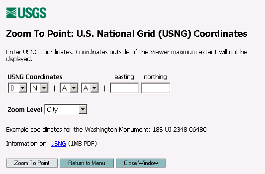
 Click the Zoom In tool and then click on a spot on the map to zoom in to that selected spot. You can also zoom in to a selected area by clicking and dragging the cursor to create a selection box over the area of interest. The displayed layers will update if any have been selected or deselected in the Layers list. Note that some layers may appear or disappear depending upon the current scale. Click the Zoom Out tool and then click on the map to zoom out. The displayed layers will update if any have been selected or deselected in the Layers list. Note that some layers may appear or disappear depending upon the current scale. Click the Zoom Back tool to return to the previously viewed map extent. Note, however, that if changes have been made to the layer selections, the previous layer selections will not be preserved. The last layer selection and the current map scale will determine what layers are displayed. You can zoom back to previously viewed map extents as many as five times. Click the Find Place tool and a popup window will open that allows the user to select from the following options: Zoom to a State�Included in the dropdown menu are the 50 States and the District of Columbia. Zoom to a Partner Dataset�Entries in the dropdown menu take you to our current Partner datasets that contain high-resolution and larger scale data. For certain partners, you may need to zoom in to see available data.  Address�Click the Zoom to an Address link and an entry form will appear in a popup window. Enter the Street Address, City, State, and Zip Code of a valid address within the United States. Partial entries of Street Address, City, and State or City and State only will zoom to the general area but may not include the street location. Street Address and Zip Code entries will center on the generalized street location within the Zip Code area. Zip Code only entries will zoom to the approximate center of the Zip Code area. Zip Codes may be entered as 5 digits or as ZIP+4 (for example, 12345-6789). Click on the Zoom to Address button to initiate the Viewer zoom action. Click on the Return to Menu button to return to the Find Place menu window. Click on the Close Window button to cancel and return to the Viewer main window.  Named Feature�Click the Geographic Name/Feature Lookup (GNIS) link to query the Geographic Names Information System (GNIS). A form will appear in a popup window. Enter at least two parameters into the form. Feature names can be searched as an "Exact Match", "Starts With" or "Contains". "Exact Match" will match only those records where the feature name is identical to the words entered. "Starts With" will match records starting with the words entered. "Contains" will match records with feature names containing the word or words entered. Click on the Submit Query button. A number of records will be displayed with basic feature information and several links for viewing the feature and accessing further information. There are two links to show the feature in the Viewer. Click on the "Zoom" link to zoom to the feature in the Viewer. Click on the "Re-center" link to re-center the Viewer on the feature, at the current scale. Click on the GNIS "Details" link to go to more detailed feature information on the GNIS Web site. The ID number is the GNIS identification number for the named feature. Click on the QuickView "DRG" or "DOQ" links to show simple images centered on the feature. There are also links to additional instructions, to send an email to a GNIS manager, and to view GNIS Frequently Asked Questions.   Zoom to a Point�Click one of three options: Longitude�Latitude, U.S. National Grid (USNG) Coordinates, or Universal Transverse Mercator (UTM) Coordinates and a corresponding entry form will appear in a popup window. For Longitude�Latitude, the default entry form is for decimal degrees but includes a link to switch to Degrees, Minutes and Seconds format. For all Zoom to Point options enter point coordinates and select an option from the Zoom Level dropdown box. The Re-center option will display the map centered on the entered coordinates at the current scale. Local, City, Region, State, and Multi-State options will set the scale at appropriate values for these features. Click on the Zoom to Point button to initiate the Viewer zoom action. Click on the Return to Menu button to return to the Find Place menu window. Click on the Close Window button to cancel and return to the Viewer main window.
Extent�Click the Zoom to Bounding Box link and an entry form will appear in a popup window. The default bounding box form is for decimal degrees, but includes a link to switch to a Degrees, Minutes and Seconds format. Enter North, South, East, and West bounds in the designated text boxes. Click on the Zoom to Extent button to initiate the Viewer zoom action. The Viewer may adjust the boundaries to fill out the display window. Click on the Return to Menu button to return to the Find Place menu window. Click on the Close Window button to cancel and return to the Viewer main window. 
Click the Full Extent tool to zoom to the full extent of the main map. Click the Re-center tool and then click on a point anywhere in the map display to re-center the map to the clicked point. When you re-center, the displayed layers will update if any have been selected or deselected in the Layers list. Alternatively, click on the small black arrows in the border surrounding the map display to pan in the direction of the arrows. Click the Identify tool and then click on the map to display information for available features at the point selected. The information will be displayed in a separate popup window. At the top of the window is a table that contains image coordinates for the point selected. Below the table is a list of layers that you can query. Note that there may not be any features available in a particular layer for the point selected, which will result in a "No features found at specified location" message or a blank page, depending on the map service that is being used at the time.  Click the Elevation tool and then click on the point of interest on the map. A popup window will show the results of your elevation query, including the surface elevation of the point clicked, the coordinates of the point clicked, and the source of the information.  Click the Measure tool and then on your starting point on the map. A green dot will appear where you click. Then click on the next point where another green dot will appear. Both the total length and the segment length will be shown in a results box at the top of the map display. Continue to click on points to create as many segments as needed. Note that only the last five green dots will show on the map, but the total length displayed is for all segments. Use the Clear tool to close the Measure tool. Click the Clear tool to close the Measure tool. Click the Print tool to print the current map view. A popup window will appear with a Create Printable Map link. It will take from 5 to 30 seconds for the map to be generated depending upon the number of layers included and the retrieval time to get these individual layers. Once the map is generated, a View Printable Map link will allow you to view the map in Adobe® Portable Document 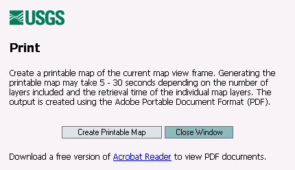 Click the Download tool to open a popup window displaying a list of extractable layers. Layers that are extractable and checked in the layer table of contents are available for download, bounded at the current viewer extent. The initial page will have all checkboxes selected. If there are any layers that you do not want to download click the checkbox next to the layer name to remove that layer from the download list. Currently vector (line-based) layers backed by ESRI� ArcIMS� map servers and certain raster (image-based) layers are extractable. Note that not all viewable layers are not downloadable. Links to raster layers available for download from The National Map Seamless Data Distribution System will be provided on the results page, as appropriate. Due to the distributed nature of The National Map application, map layers will be downloaded from one or more servers. The results page will contain a link to a ZIP-archived data bundle, one for each extract server. Processing time should take from 5-30 seconds. There is a server timeout period of 30 seconds. If an extract server does not respond within the timeout period no results will be listed on the results page for that server.  Click the Options tool to open a popup window to change Viewer options. The Redraw Map option affects when the map is  Click to bring up the Help menu in a separate window. |
|
U.S. Department of the Interior ||
U.S. Geological Survey 12201 Sunrise Valley Drive, Reston, VA 20192, USA URL: http://nationalmap.usgs.gov/nmjump.html Maintainer: Geography Webmaster Last modified: Monday, 16-Aug-2004 06:29:01 EDT |
 |
|
|