
USGS/Cascades Volcano Observatory, Vancouver, Washington
CVO Photo Archives -
Lahars, Debris Flows, and Mudflows
-
 [Image,73K,JPG]
An explosive eruption at Mount St. Helens
on March 19, 1982, sent pumice and ash 9 miles (14 kilometers)
into the air, and resulted in a lahar (the dark deposit on the snow)
flowing
from the crater into the North Fork Toutle River valley.
Part of the lahar
entered Spirit Lake (lower left corner) but most of the flow
went west down the
Toutle River, eventually reaching the Cowlitz River, 50 miles (80 kilometers)
downstream.
-- USGS Photo by Thomas J. Casadevall, March 21, 1982
-
 [Image,260K,GIF]
Aerial oblique view south towards Mount St. Helens.
The dark area is path of a huge
snow avalanche, slushflow, and flood, all caused by swift
melting and sliding of snowpack induced by small explosive
eruption from dome on March 19, 1982.
-- USGS/CVO Photo, March 25, 1982
-
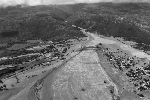
 [Image,113K,GIF]
Toutle River, looking west from Highway 99 Bridge.
Interstate 5 Bridge in middle left background.
Note mudlines left behind on trees.
This area was later logged and dredged.
-- USGS Photo by Lyn Topinka, July 6, 1980
-
 [Image,95K,JPG]
Nearly 135 miles (220 kilometers) of river channels surrounding
Mount St. Helens were
affected by the lahars of May 18, 1980.
A mudline left behind on trees shows depths
reached by the mud. A scientist (middle right) gives scale.
This view is along the Muddy River, southeast of Mount St. Helens.
-- USGS Photo by Lyn Topinka, October 23, 1980
-
 [Image,102K,JPG]
More than 200 homes and over 185 miles (300 kilometers) of roads were
destroyed by mudflows from Mount St. Helens in 1980.
Pictured here is a damaged home along the
South Fork Toutle River.
-- USGS Photo by Lyn Topinka, July 19, 1981
-
 [Image,76K,JPG]
Debris flow at Tahoma Creek, July 26, 1988
-- USGS Photo by G. G. Parker, USGS/WRD/Tacoma
-
 [Image,76K,JPG]
Debris flow aftermath at Tahoma Creek, October 1, 1987.
-- USGS Photo by Lyn Topinka, October 1, 1987
-
 [Image,84K,JPG]
Armero, Colombia, destroyed by lahar on November 13, 1985.More than 23,000 people were killed in Armero
when lahars (volcanic debris flows) swept down from the erupting Nevado del Ruiz volcano. When the volcano became
restless in 1984, no team of volcanologists existed that could rush to the scene of such an emergency. However, less than a
year later, the U.S. Geological Survey organized a team and a portable volcano observatory that could be quickly
dispatched to an awakening volcano anywhere in the world.
USGS Photo by R. J. Janda, 1985
Return to:
[CVO Photo Archives Menu] ...
[Lahar and Mudflow Menu] ...

Use of CVO Material and Copyright Information
URL for CVO HomePage is:
<http://vulcan.wr.usgs.gov/home.html>
URL for this page is:
<http://vulcan.wr.usgs.gov/Glossary/Lahars/images.html>
If you have questions or comments please contact:
<GS-CVO-WEB@usgs.gov>
03/24/02, Lyn Topinka
 Use of CVO Material and Copyright Information
 [Image,73K,JPG]
 [Image,260K,GIF]
 [Image,113K,GIF]
 [Image,95K,JPG]
 [Image,102K,JPG]
 [Image,76K,JPG]
 [Image,76K,JPG]
 [Image,84K,JPG]