Mount St. Helens Precursory Activity
May 10 - 17, 1980
|
|
Near the Breaking Point - Cloudy weather gave way to sunshine later in the week. Earthquake activity remained at or below previous levels. Explosions ceased on the 15th, but the bulge continued its inexorable growth. Many property owners in the Spirit Lake area increased pressure on local authorities to allow them access to their holdings - they were successful. On May 17 a group of property owners to signed waivers and escorted by authorities into the Spirit Lake area to retrieve possessions. Another escorted trip was planned for the morning of May 18. |
|
Constant Change Scientists from the USGS continued to monitor the growth of the bulge. Although other outward signs of activity diminished, the changes measured by repeated surveys showed a nearly constant rate of deformation of the north flank of the volcano. |
 Aerial photo of crater (light gray ash-covered area) and bulge (dark area,
to right). The crater area continued to subside as the bulge pushed outward at an average
5 feet per day. USGS photo courtesy of Dan Miller.
|
|
 Plot showing displacements of EDM targets from April through May 17, 1980.
Deformation continued at a nearly constant rate as evidenced by the relatively
straight slope of lines. Modified from USGS Professional Paper 1250, p. 150.
|
|
Daily Log |
|
May 10 - The volcano remained under clouds most of the day. Steam and ash emissions were visible once the weather cleared. Surveys of the bulge showed that the outward motion had slowed to less than 3 feet per day, about half the average rate for the previous two weeks. The low rate was later considered to be the result of an erroneous measurement. There were 20 earthquakes larger than magnitude 3.0 recorded, including 10 larger than 4.0. Professor Al Eggers of the University of Puget Sound told reporters that tide-producing gravitational forces will be exceptionally strong on May 21. He warned that the extreme force might trigger an eruption if the volcano were already set to erupt. Although most USGS scientists did not totally discount the idea, many believed other factors such as magmatic pressure inside the mountain were likely more important. May 11 - Small bursts of steam and ash were emitted. There were 24 earthquakes larger than magnitude 3.0 recorded, including 10 larger than 4.0. Increased steaming was observed at the upper Shoestring Glacier fumarole. Most USGS and UW scientists believe any major eruption would be preceded by a change in the seismic activity or rate of bulging. If the patterns do not change before the onset of a major event - such as the expected massive avalanche - they may be unable to provide advance warning. |
|
|
May 12 - Small explosions continued. Observers noted a cluster of fumaroles on the western rim of the crater. There were 28 earthquakes larger than magnitude 3.0 recorded, including 8 larger than 4.0. A magnitude 5.0 earthquake triggered an 800 foot wide avalanche down the north flank. Scientists believed this avalanche demonstrated the increased instability of the north flank and a sample of larger events to come. UW seismologists moved a portable seismic recorder from Spirit Lake to a ridgetop northeast of the volcano. The instrument could have been destroyed if an avalanche reached Spirit Lake. |
|
|
May 13 - Steam and ash explosions decreased in frequency. Most ash fell near the crater. Steam emission increased from the Shoestring fumarole. A false report that a large eruption had sent ash to 18,000 feet prompted FAA officials to issue a pilot's warning that an ash plume extended 20 miles to the north-northeast and was "of extreme hazard to aircraft." |
|
May 14 - Poor weather obscured the volcano for half the day. A new steam vent was visible between the two small peaks on the northern crater rim. The north flank continued to bulge outwards at about 5 feet per day. Seismicity remained at about the same or slightly lower level than in previous days. Scientists from Dartmouth reported measurements of sulfur dioxide at 10 to 20 tons per day during explosions and about 1 ton per day between explosions. A crank phone call reporting flowing lava was placed to KING TV in Seattle. Within minutes rumors of the lava had reached Portland and Vancouver. According to USGS scientist Bob Decker, "it was a rumor spread by people trying to confirm a rumor." |
|
|
May 15 - Explosions ceased, but new ash was visible on the southwestern flank. Some summit vents appeared to be filled with fallen blocks of ice. The bulge continued to push outward at about 5 feet per day. Seismic activity included an earthquake of magnitude 4.8. Fifty days have passed since the first explosion (March 27), yet there has been no sign of fresh magma in the ash. Continued activity has attracted tourists from around the world. Many congregated at roadblocks for picnicing, socializing, or waiting for the clouds to clear. Three workers were flown in to evacuate equipment from the YMCA and Boy Scout camps on Spirit Lake. |
 Explosions ceased on May 15. The crater remained quiet up to the morning
of May 18. From May 14-18 only the steady outward movement of the bulge warned scientists
that the danger was far from over. USGS photo courtesy of Dan Miller.
|
|
May 16 - No explosions were reported. There were 28 earthquakes larger than magnitude 3.0 recorded, including 10 larger than 4.0. There have been no records of harmonic tremor since May 8. Steam continued to emanate from the summit area. Portions of the upper reaches of the bulging north flank were also steaming. The shape of the volcano has changed considerably during the past 10 days. The north and northwest rims of the crater have abundant cracks that are partially filled with snow and ash. The area appears to be moving downward as a mass toward the crater. The bulge continued to appear highly broken and distorted. Before dawn Department of Energy personnel made an aerial infrared survey. The data were not immediately available for interpretation. Glaciologists placed a time-lapse camera on Dogs Head aimed at the growing bulge. Owners of private property in the Red Zone demanded access to homes and cabins they were forced to leave weeks ago. Some threatened to converge on the roadblocks in numbers and go through "come hell or high water." The National Weather Service predicted good weather for volcano watching for the coming weekend. |
|
|
May 17 - The mountain remained quiet. Seismic activity reached the lowest level for May, with only 18 earthquakes larger than 3.0 recorded (including 6 larger than magnitude 4.0). In response to pressure from property owners and with the Governor's consent, law enforcement officials escorted about 50 carloads of property owners into the Red Zone to retrieve possessions. Those who entered were required to sign liability waivers at the roadblocks and to leave by nightfall. Authorities agreed to allow another caravan of property owners in at 10:00 a.m. the following morning. |
 This photo of USGS geologist Dave Johnston was taken on the afternoon of
May 17, 1980, as Dave took over duties at the Coldwater II observation site less than
5 miles north of the volcano. On the morning of May 18 Dave Johnston, along with 56 others,
died as a result of a major eruption of Mount St. Helens. USGS photo courtesy of Harry .
Glicken.
|
|
|

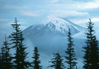
 Mount St. Helens from the north, May 10, 1980. USGS photo courtesy of
Dan Miller.
 Contour map showing changes in elevation between May 1 and May 12. Blue
contours indicate elevation gain, red contours elevation loss. The map illustrates the
continued growth of the bulge and subsidence of the crater area. Modified from USGS
Professional Paper 1250, p. 126.
 Small steam and ash explosions between May 7 and 15 rarely sent ash
beyond the crater. USGS photo courtesy of Dan Miller.
 Phreatic explosion. USGS photo courtesy of Dan Miller.
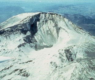
 Aerial view of crater taken on May 17, 1980. USGS photo courtesy of
Dan Miller.
 Aerial profile of Mount St. Helens from the east. Note size of bulge
on north (right) side of volcano. USGS photo courtesy of Dan Miller.
 USGS scientist conducts survey of Mount St. Helens from Butte Camp
Dome. USGS photo courtesy of Don Swanson.
