USGS/CVO Logo, click to link to National USGS Website
USGS/Cascades Volcano Observatory, Vancouver, Washington

The Volcanoes of Lewis and Clark

November 4, 1805

Vancouver, Washington -
Columbia River Slough to Ridgefield NWR

 
Home
-- The Volcanoes of Lewis and Clark

Map of the Journey
-- Volcanoes, Basalt Plateaus, Major Rivers, etc.

CALENDAR of the Journey
-- October 1805 to June 1806

Along the Journey
-- Pacific Northwest Maps - Columbia River, Volcanoes, Flood Basalts, Missoula Floods, Geology, etc.

The Corps of Discovery
-- The Journey of Lewis and Clark

About the Reference Materials
-- The Journals, Biddle/Allen, DeVoto, Gass, Moulton, Topo Maps, and others

USGS Lewis and Clark Links
-- Links to USGS Websites highlighting the Lewis and Clark Journey

Resources
Publications Referenced and Websites Visited

PREVIOUS

November 3
Columbia River Heading West, Rooster Rock to Columbia River Slough
November 4

Vancouver, Washington,
Columbia River Slough to Ridgefield NWR

Government Island, Portland International Airport, Prairie and Pond, Fort Plain, Ryan Point, Tomahawk Island, Fort Vancouver and Vancouver (Washington), Fort Vancouver National Historic Site, Hayden Island, Interstate-5 Bridge, Mouth of the Willamette River, Willamette River, Portland, Oregon, FIVE VOLCANOES, Puget Trough and the Willamette Valley, Boring Lava Field, Sauvie Island, Mount St. Helens and Mount Hood, Vancouver Lake and Vancouver Lake Park, Sthillapoo-Vancouver Wildlife Area, Ridgefield NWR, Portland's West Hills
CONTINUE

November 5
Heading to the Pacific, Ridgefield NWR to Prescott Beach, Oregon
 

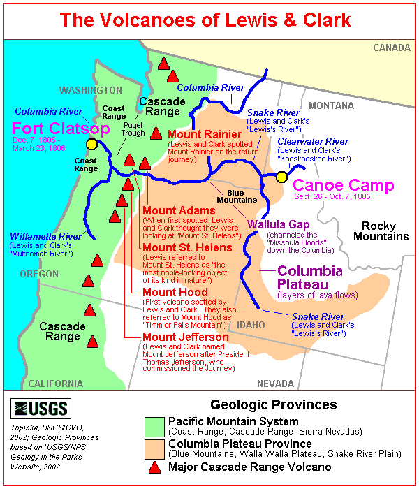
On October 7, 1805, Lewis and Clark and the "Corps of Discovery" began their journey down the Clearwater River and into the volcanics of the Pacific Northwest. The Corps travelled from the Clearwater to the Snake and down the "Great Columbia", finally reaching the Pacific Ocean on November 15, 1805. Along the journey they encountered the lava flows of the Columbia Plateau, river channels carved by the great "Missoula Floods", and the awesome beauty of five Cascade Range volcanoes.


Map, Lewis and Clark in the Pacific Northwest
(Click map for brief summary about the area)


The Volcanoes of Lewis and Clark
To the Pacific - November 1805
Vancouver, Washington
Columbia River Slough to Ridgefield NWR

Monday, November 4, 1805

Lewis and Clark's camp of November 3, 1805, as located on the north shore of "Diamond Island" (Government Island).


Along the Journey - November 4, 1805
Map, 1887, Camas and Washougal vicinity, click to enlarge NASA Image, 1992, Aerial view Columbia River with Portland, Oregon, and Vancouver, Washington, click to enlarge NASA Image, 1992, Aerial view Columbia River and Government Island, click to enlarge Image, 1982, I-205 Bridge between Washington and Oregon, click to enlarge Government Island:
  1. 1887 Map (section of original), Columbia River and the Camas and Washougal vicinity, including Government Island. (Click to enlarge). Government Island, while not named on this map, is the large island located to the left of Lady Island, the island located at the mouth of the Washougal River. Original Map: The Columbia River from Celilo to the mouth showing locations of the salmon fisheries, 1887. Scale ca. 1:375,000, Relief shown by hachures. U.S. Army Corps of Engineers, Engineer Office, G.P.O. 1888. University of Washington Archives #UW128. -- University of Washington Library Archives Website, 2002
  2. 1992, NASA Image, Columbia River, Portland, Oregon, and Vancouver, Washington (section of original). (Click to enlarge). View from space - west-looking, low-oblique photograph, showing a section of the Columbia River with Government Island, the Sandy River, Portland, Oregon, and Vancouver, Washington, September 1992. The Columbia River is flowing from bottom (east) to top (west). NASA Earth from Space #STS047-096-066. -- NASA Earth from Space Website, 2002
  3. 1992, NASA Image, Closer-in view, Columbia River and Government Island (section of original). (Click to enlarge). View from space - West-looking, low-oblique photograph, showing a section of the Columbia River with Government Island, September 1992. Interstate 205 (white line, center) can be seen crossing Government Island from Portland, Oregon (left) to Vancouver, Washington (right). NASA Earth from Space #STS047-096-066. -- NASA Earth from Space Website, 2002
  4. 1982, I-205 Bridge crosses Government Island as it spans the Columbia River between Washington State (top) and Oregon (bottom). (Click to enlarge). Mount St. Helens can faintly be seen on the horizon (middle left). -- Oregon Department of Transportation Website, 2002

Government Island:
Government, Lemon and McGuire Islands are located in the Columbia River northeast of Portland International Airport between River Mile 111.5 and River Mile 119. The island complex, consists of approximately 2,200 acres. On November 3, 1805, Lewis and Clark called the island "Diamond Island", because of its shape. The Lewis and Clark maps indicate that what is now known as "Government Island" was then divided into two large islands, besides smaller ones, and it was the upper of the two larger islands that was named "Diamond". The lower island was not named in the text, but the maps show it and another islet to the west as "White Goose Island". This western islet is probably the "Lemon Island" of today. The two larger islands are now consolidated, though part of the dividing channel still exists. At the time of Lewis and Clark the western of the two larger islands was nearly consolidated with the islet to the west. In February, 1850, the government reserved this island for military purposes, and raised hay on it. It was then called "Miller's Island". The name, "Government Island", came into use after government occupation. -- McArthur, 1982, Oregon Geographic Names, and Port of Portland Website, 2002


Government Island State Recreation Area:
Access to Government Island is by boat only. There are two docks and a floating tie-up on the north side of the island. With 15 miles of shoreline and a free primitive campground, the park is popular with anglers. The interior of the island is still used as a cattle ranch and also contains protected natural areas. Entry to the interior is prohibited. -- Oregon State Parks and Recreation Website, 2003


History of Government Island:
On October 29, 1792, Lieut. Broughton spent the night in the vicinity of Government Island. He spent the day of October 30 exploring the Columbia River to a point above the Sandy River, and returning in the evening, he camped not far from his position of the previous night. On November 3, 1805, Lewis and Clark camped on Government Island which they called Diamond Island because of its shape. They described it in their journals as "mostly prairie with a large pond full of swans, geese and ducks." The islands were surveyed in 1841 by the U.S. government; at that time Lemon Island was called Smiths Island, and Government Island was divided into three separate islands called Romer, Sandy and Douglass; McGuire was not visible on the survey. In February 1850 the Government reserved Romer, Sandy and Douglass Islands for military purposes and raised hay; from then on they were called Government Island. In the 1902 the U.S. Coast and Geodetic Survey surveyed the island complex; by that time natural sedimentation processes had merged the three islands and forest and marsh habitat were configured similar to current conditions. The islands have been under Port of Portland ownership (with the exception of a 224 acre parcel at the east end of Government Island which is owned by Metro Regional Parks and Greenspaces Department (Metro)) since 1969 when they were purchased from the Oregon State Game Commission for a proposed expansion of Portland International Airport. Although the runway expansion project was canceled, the Port has continued to maintain ownership of the islands as open space to ensure that no conflicting uses (e. g. housing) are developed under this section of the primary flight path east of the airport. -- McArthur, 1982, Oregon Geographic Names, and Port of Portland Website, 2002


The weather was cloudy and cool, and the wind from the west. During the night, the tide rose eighteen inches near our camp. We set out about eight o'clock, and at the distance of three miles came to the lower end of Diamond island [Government Island]. It is six miles long, nearly three in width, and like the other islands, thinly covered with timber, and has a number of ponds or small lakes scattered over its surface. Besides the animals already mentioned we shot a deer on it this morning. Near the end of Diamond island [Government Island] are two others, separated by a narrow channel filled at high tides only, which continue on the right for the distance of three miles, and like the adjacent low grounds, are thickly covered with pine. Just below the last, we landed on the left bank of the river, at a village of twenty-five houses [today's Portland International Airport]. ......


Along the Journey - November 4, 1805
Portland International Airport:
Visited twice by the Corps, this former site of a Neerchokioo village was a temporary Shahala Indian residence for gathering wapato (potato-like water root) and is now under the airport parking structure. 10 miles east of downtown Portland, Oregon. -- Lewis and Clark Bicentennial in Oregon Website, 2002


We resumed our journey, and at seven miles distance came to the head of a large island near the left [Hayden Island, see information below]. On the right shore is a fine open prairie [Fort Plain, today's Vancouver, Washington, area around Fort Vancouver and Pearson Airpark] for about a mile, back of which the country rises, and is supplied with timber, such as white oak, pine of different kinds, wild crab, and several species of undergrowth, while along the borders of the river, there are only a few cottonwood and ash trees. In this prairie were also signs of deer and elk.
"... I walked out on the Stard. Side found the country fine, an open Prarie [Fort Plain] for 1 mile back of which the wood land comence riseing back ...... a Pond on the Stard Side, off from the river. [Many ponds, now filled in, were in this area around Ryan Point, Fort Vancouver, and Pearson Airpark] ..." [Clark, November 4, 1805, first draft]
"... at 7 miles below this village passed the upper point of a large Island nearest the Lard. Side [Hayden Island] , a Small Prarie [Fort Plain] in which there is a pond opposit on the Stard. [Vancouver area around Ryan Point, Fort Vancouver, and Pearson Airpark] Here I landed and walked on Shore, about 3 miles a fine open Prarie for about 1 mile, back of which the countrey rises gradually and wood land comencies ..." [Clark, November 4, 1805]


Along the Journey - November 4, 1805
Prairie and Pond:
The "Prarie" is undoubtedly the Fort Plain prairie that stretched from the Fort Vancouver village area to Marine Park and the Water Resources Education Center. ... The "Pond" would be one of the ponds in the Point Ryan area east and south of today's Pearson Airpark. -- U.S. National Park Service, Vancouver National Historic Reserve Website, 2003, and Moulton, Vol.I., NOAA Office of Coast Survey Website, 2003, and "The Columbian" Website, 2002, Lewis and Clark Bicentennial


Fort Plain:
The Vancouver National Historic Reserve is located on a former area of prairie and wetlands that formed a highly productive location for native food resources. In the mid-19th century, this place was called "Fort Plain" through its association with the Hudson's Bay Company's Fort Vancouver. Fort Plain was the terminus of the "Klickitat Trail" that linked the interior Klickitat and Taidnapam people to the riverine Chinook people, and linked the resources of the river (smelt, sturgeon, salmon, and wapato), with that of the prairies and mountains (camas, oak, berries, game animals) (Norton, et al. 1983). Prehistoric artifacts found at Fort Vancouver National Historic Site confirm that American Indians occupied fort plain long before Lewis & Clark arrived. Fort Plain has been identified as a Lewis and Clark stopping place associated with their travels down the Columbia River on November 4, 1805, and a campsite during their travels up the Columbia on March 30, 1806. The journals identify a small prairie and pond at the upstream point of a large island, corresponding to modern Tomahawk Island. -- U.S. National Park Service, Fort Vancouver Historic Reserve Website, 2003


Ryan Point:
Along the Columbia River 1.4 miles east-southeast of the Interstate-5 highway bridge (just south and upstream of Vancouver's Pearson Air Park), lies Vancouver's most obscure major historical site -- Ryan Point. There's no sign today among the tugboats and cranes to show that Lewis and Clark landed at the point 195 years ago, or that the explorers hunkered down for the night with 30 companions 500 yards northwest of the point on March 30, 1806. Ryan Point is behind Building 33, a huge warehouse in Columbia Business Center. At 2.4 million square feet, the center is one of the largest industrial parks in the Vancouver-Portland area. Lewis and Clark's 1806 campsite near Ryan Point, at present-day Columbia River Drive and Columbia Shores Boulevard, is out of sight. It's covered with condominiums. [see March 30, 1806 entry] -- NOAA Office of Coast Survey Website, 2003, and "The Columbian" Website, 2002, Lewis and Clark Bicentennial


When we landed for dinner, a number of Indians from the last village, came down for the purpose, as we supposed, of paying us a friendly visit, as they had put on their favourite dresses. ...... We smoked with them and endeavoured to show them every attention, but we soon found them very assuming and disagreeable companions. ......
"... dureing the time we were at dinner those fellows Stold my pipe Tomahawk which they were Smoking with, I imediately Serched every man and the canoes, but Could find nothing of my Tomahawk ..." [Clark, November 4, 1805]


Along the Journey - November 4, 1805
Tomahawk Island:
A small island between "Image Canoe Island" and the north shore of the river was given the name "Tomahawk Island," after an incident during which Clark's tomahawk pipe was stolen. Clark visited a village on the mainland but was unable to determine the location of a river that geographic intuition indicated must be present in the area. The island was eventually washed away, but in 1927 the United States Board of Geographic Names (USBGN) was petitioned to assign the name to a new island that formed on the east end of Hayden Island. The Lewis and Clark name was perpetuated by naming a new island after one that has washed away. Tomahawk and Hayden islands have now almost been consolidated by river silting and road construction. -- Washington State Historical Society Website, 2003


We then proceeded [Vancouver, Washington/Fort Vancouver vicinity]


Along the Journey - November 4, 1805
Map, 1855, Columbia River, Vancouver to the Pacific, click to enlarge Map, 1887, Portland and Vancouver vicinity, click to enlarge NASA Image, 1992, Aerial view Columbia River with Portland, Oregon, and Vancouver, Washington, click to enlarge NASA Image, 1992, Closer-in Aerial view Columbia River at the Mouth of the Willamette, click to enlarge Image, 1990, Columbia River looking west, Vancouver Lake, click to enlarge Engraving, 1850, Fort Vancouver and Mount Hood, click to enlarge Fort Vancouver and Vancouver, Washington:
  1. 1855 Map, Columbia River from Vancouver to the Pacific (section of original). (Click to enlarge). Original Map: "Map of Oregon and Washington Territories: showing the proposed Northern Railroad route to the Pacific Ocean, by John Disturnell, 1855. University of Washington Archives #UW155. -- University of Washington Library Collections Website, 2002
  2. 1887 Map (section of original), Columbia River and the Portland and Vancouver vicinity. (Click to enlarge). Original Map: The Columbia River from Celilo to the mouth showing locations of the salmon fisheries, 1887. Scale ca. 1:375,000, Relief shown by hachures. U.S. Army Corps of Engineers, Engineer Office, G.P.O. 1888. University of Washington Archives #UW128. -- University of Washington Library Archives Website, 2002
  3. 1992, NASA Image, Columbia River, Portland, Oregon, and Vancouver, Washington (section of original). (Click to enlarge). View from space - west-looking, low-oblique photograph, showing a section of the Columbia River with Government Island, Sandy River, Portland, Oregon, and Vancouver, Washington, September 1992. The Columbia River is flowing from bottom (east) to top (west). NASA Earth from Space #STS047-096-066. -- NASA Earth from Space Website, 2002
  4. 1992, NASA Image, Columbia River at the mouth of the Willamette (section of original). (Click to enlarge). View from space - West-looking, low-oblique photograph, showing a section of the Columbia River with Government Island, September 1992. Portland, Oregon is to the left and Vancouver, Washington is to the right. NASA Earth from Space #STS047-096-066. -- NASA Earth from Space Website, 2002
  5. 1990, Aerial view, Columbia River looking west, with Vancouver Lake on the right. (Click to enlarge). Columbia River at Portland and Vancouver, looking west. Oregon is to the left and Washington State is to the right. Vancouver Lake is on the right. Photographer: Bob Heims. Photograph Date: June 21, 1990. U.S. Army Corps of Engineers Photo Archives #Col0502.jpg -- U.S. Army Corps of Engineers Photo Archives Website, 2003
  6. 1850 Engraving, Fort Vancouver, with Mount Hood in the background. (Click to enlarge). Engraving by: Gustave Sohon, November 1850. Image from U.S. War Dept.'s Reports of explorations and surveys to ascertain the most practicable and economical route for a railroad from the Mississippi River to the Pacific Ocean, 1860, v. 12, pt.1, pl.44. University of Washington Libraries Collection #NA4171. -- University of Washington Archives Website, 2002

Fort Vancouver and Vancouver, Washington:
In May, 1792, American trader/sailor Robert Gray became the first non-native to enter the fabled "Great River of the West," the Columbia River. Later that year, British Lt. William Broughton, serving under Capt. George Vancouver, explored 100 miles upriver. Along the way, he named a point of land along the shore in honor of his commander. In 1806, American explorers Meriwether Lewis and William Clark camped near the Vancouver waterfront on the return leg of their famed western expedition. Lewis characterized the area as "the only desired situation for settlement west of the Rocky Mountains." In 1825, Dr. John McLoughlin decided to move the northwest headquarters of the Hudson's Bay Company from Astoria to a more favorable setting upriver. He named the site after Point Vancouver on Broughton's original map. Fort Vancouver was thus born. The new site was on the north bank of the Columbia, slightly upstream from the mouth of the Willamette River on the opposite side. The fort itself, after an initial, arduous four years on a nearby bluff, would be built on a plain with easy access to the water, but just beyond the flood plain. The surrounding environment was broad areas of prairie and trees, sloping upward to dense fir forests; it was known as Jolie Prairie or Belle Vue Point because of its intense natural beauty. McLoughlin's superiors were well pleased with the choice, not only for its situation, but most importantly for its rich pasture and amenable climate. -- City of Vancouver Website, 2002, and U.S. National Park Service Website, Fort Vancouver National Historic Site, 2002


Fort Vancouver National Historic Site:
Fort Vancouver became a National Monument in 1948 and a National Historic Site in 1961. In 1996, the 366-acre Vancouver National Historic Reserve was established to protect adjacent, historically significant historical areas. It includes Fort Vancouver National Historic Site, as well as Vancouver Barracks, Officers' Row, Pearson Field, The Water Resources Education Center, and portions of the Columbia River waterfront. The General O.O. Howard House serves as the visitor center for the Reserve, and is staffed by National Park Service personnel. -- U.S. National Park Service Website, Fort Vancouver National Historic Site, 2002


and soon met two canoes with twelve men of the same Skilloot nation, who were on their way from below. The larger of the canoes was ornamented with the figure of a bear in the bow, and a man in the stern, both nearly as large as life, both made of painted wood, and very neatly fixed to the boat. In the same canoe were two Indians finely dressed and with round hats. This circumstance induced us to give the name of Image canoe to the large island [Hayden Island], the lower end of which we now passed at the distance of nine miles from its head.


Along the Journey - November 4, 1805
Map, 1887, Portland and Vancouver vicinity, click to enlarge NASA Image, 1992, Aerial view Columbia River with Portland, Oregon, and Vancouver, Washington, click to enlarge NASA Image, 1992, Aerial view Columbia River, Willametter River, and Hayden Island, click to enlarge Hayden Island:
  1. 1887 Map (section of original), Columbia River and the Portland and Vancouver vicinity, including Hayden Island. (Click to enlarge). Hayden Island, while not named, is the long island between Vancouver, Washington and Portland, Oregon. The diamond-shaped island upstream (to the right) is Government Island. Original Map: The Columbia River from Celilo to the mouth showing locations of the salmon fisheries, 1887. Scale ca. 1:375,000, Relief shown by hachures. U.S. Army Corps of Engineers, Engineer Office, G.P.O. 1888. University of Washington Archives #UW128. -- University of Washington Library Archives Website, 2002
  2. 1992, NASA Image, Columbia River, Portland, Oregon, and Vancouver, Washington (section of original). (Click to enlarge). View from space - west-looking, low-oblique photograph, showing a section of the Columbia River with Government Island, Hayden Island, Lady Island, Sandy River, Washougal River, and Portland, Oregon and Vancouver, Washington, September 1992. The Columbia River is flowing from bottom (east) to top (west). NASA Earth from Space #STS047-096-066. -- NASA Earth from Space Website, 2002
  3. 1992, NASA Image, Closer-in, Columbia River, Willamette River, and Hayden Island (section of original). (Click to enlarge). View from space - west-looking, low-oblique photograph, showing a section of the Columbia River, Willamette River, and Hayden Island, September 1992. Near the top of the photo the Willamette River meets the Columbia River. Just upstream (below on photo) is Hayden Island, just barely discernible as an island in this view from space. The lower half (eastern) of Hayden Island is commercially developed while the upper half (western) of Hayden Island is open space. The Interstate-5 bridge is visible crossing the Columbia River from Portland Oregon (left) to Vancouver, Washington (right). NASA Earth from Space #STS047-096-066. -- NASA Earth from Space Website, 2002

Hayden Island:
Hayden Island was discovered on October 19, 1792, by W.R. Broughton, who called the island "Menzies Island", after the botanist on the voyage. On October 30, 1792, however, Broughton called the island "Goose Island". Lewis and Clark reached Hayden Island on November 4, 1805, and named it "Image Canoe Island", where they met a canoe with carved images at the bow. (Thwaites, editing the journals however mis-identified Image Canoe Island with Wapato Island, which is now called Sauvie Island.) Hudson's Bay Company called the island "Vancouver Island". During the 19th century the island bore the name of "Shaw's Island", for Col. W. Shaw, who had property there. Hayden Island was eventually renamed for Gay Hayden, an early major of Vancouver, who bought land on the island. -- Lewis McArthur, 1982, Oregon Geographic Names, and 'The Columbian' Website, 2002, Clark County History


Connecting Vancouver, Washington with Hayden Island and Portland, Oregon, is the Interstate-5 Bridge.


Along the Journey - November 4, 1805
NASA Image, 1992, Columbia River, Willamette River, and Hayden Island, click to enlarge Image, 1993, Interstate-5 bridge spanning the Columbia from Vancouver to Portland, click to enlarge Interstate-5 Bridge:
  1. 1992, NASA Image, Columbia River, Willamette River, and Hayden Island (section of original). (Click to enlarge). View from space - West-looking, low-oblique photograph, showing a section of the Columbia River, Willamette River, and Hayden Island, September 1992. Near the top of the photo the Willamette River meets the Columbia River. Just upstream (below on photo) is Hayden Island, just barely discernible as an island in this view from space. The lower half (eastern) of Hayden Island is commercially developed while the upper half (western) of Hayden Island is open space. The Interstate-5 bridge is visible crossing the Columbia River from Portland Oregon (left) to Vancouver, Washington (right). NASA Earth from Space #STS047-096-066. -- NASA Earth from Space Website, 2002
  2. 1993, Interstate-5 Bridge spanning the Columbia River from Vancouver, Washington (right) to Portland, Oregon (left). (Click to enlarge). The 1915-1917 bridge is in the foreground with the 1956 span visible behind. -- U.S. Library of Congress Website, 2003, American Memories

Interstate-5 Bridge:
Between 1915 and 1917, one of the largest bridges ever built up until this time was constructed over the Columbia River, between Vancouver, Washington and Hayden Island, Oregon. But the spanning of this bridge was more than a feat of engineering. Its construction signified an unprecedanted degree of co-operation between the citizens of Multnomah County, Oregon and Clark County, Washington who, dissatisfied with the inadequacies of the existing ferry system - the only connecting link for pedestrians and automobiles in this vicinity - eagerly rallied to the cause of an interstate bridge campaign. The bridge paved the way for a new era in automobile transportaion in the region, an era that developed so rapidly that a sedon, almost identical structure had to be bult alongside it some forty years later to keep pace with the enormous increase in interstate traffic. Date of construction: 1915-1917 northbound, and 1956 southbound. -- U.S. Library of Congress Website, 2003, American Memories


We had seen two smaller islands to the right, and three more near its lower extremity. The Indians in the canoe here made signs that there was a village behind those islands, and indeed we presumed there was a channel on that side of the river, for one of the canoes passed in that direction between the small islands, but we were anxious to press forward, and therefore did not stop to examine more minutely.


In 1806, on the return trip home, Lewis and Clark were to discover the mouth of the Willamette River, the location of today's Portland, Oregon


Along the Journey - November 4, 1805
Map, 1887, Portland and Vancouver vicinity, click to enlarge NASA Image, 1992, Aerial view Columbia River with Portland, Oregon, and Vancouver, Washington, click to enlarge Image, 1988, Willamette River and Portland, Oregon, click to enlarge Willamette River:
  1. 1887 Map (section of original), Columbia River and the Portland and Vancouver vicinity, including the Willamette River. (Click to enlarge). Original Map: The Columbia River from Celilo to the mouth showing locations of the salmon fisheries, 1887. Scale ca. 1:375,000, Relief shown by hachures. U.S. Army Corps of Engineers, Engineer Office, G.P.O. 1888. University of Washington Archives #UW128. -- University of Washington Library Archives Website, 2002
  2. 1992, Aerial view, Columbia River, Portland, Oregon, and Vancouver, Washington (section of original). (Click to enlarge). View from space - west-looking, low-oblique photograph, showing a section of the Columbia River with Government Island, the Sandy River, Portland, Oregon, and Vancouver, Washington, September 1992. The Columbia River is flowing from bottom (east) to top (west). NASA Earth from Space #STS047-096-066. -- NASA Earth from Space Website, 2002
  3. 1988 view of the Willamette River and the city of Portland, Oregon. Looking south with the Fremont Bridge in the foreground. (Click to enlarge). U.S. Army Corps of Engineers Photograph #Sce0373. Photograph Date: June 1988. Photographer: Bob Heims. U.S. Army Corps of Engineers Photo Archives. -- U.S. Army Corps of Engineers Website, 2002

Willamette River:
Most of Oregon's population, technology and agricultural centers, and important transportion, power, and communications lifelines are located in the Willamette Valley of western Oregon. The lowlands of the Willamette Valley extend about 75 miles along the Willamette River and contain the major cities of Portland, Salem, Corvallis, and Eugene. The valley is part of the Willamette River drainage basin, which covers 12,300 square miles between the crest of the Oregon Coast Range on the west and the Cascade Range to the east. The Willamette River is the largest river in the valley and is fed by several major tributaries, including the McKenzie, Calapooia, Santiam, Tualatin, Yamhill, and Clakamas Rivers. The valley is the major source of ground and surface water for the population centers. -- Givler and Wells, 2001


Today, Portland, Oregon, is located on the Willamette River, sightly upstream from the Willamette's confluence with the Columbia River.


Along the Journey - November 4, 1805
Map, 1855, Columbia River, Vancouver to the Pacific, click to enlarge Map, 1887, Portland and Vancouver vicinity, click to enlarge NASA Image, 1992, Aerial view Columbia River with Portland, Oregon, and Vancouver, Washington, click to enlarge NASA Image, 1992, Closer-in Aerial view Columbia River at the Mouth of the Willamette, click to enlarge Image, 1988, Willamette River and Portland, Oregon, click to enlarge Portland, Oregon:
  1. 1855 Map, Columbia River from Vancouver to the Pacific (section of original). (Click to enlarge). Original Map: "Map of Oregon and Washington Territories: showing the proposed Northern Railroad route to the Pacific Ocean, by John Disturnell, 1855. University of Washington Archives #UW155. -- University of Washington Library Collections Website, 2002
  2. 1887 Map (section of original), Columbia River and the Portland and Vancouver vicinity. (Click to enlarge). Original Map: The Columbia River from Celilo to the mouth showing locations of the salmon fisheries, 1887. Scale ca. 1:375,000, Relief shown by hachures. U.S. Army Corps of Engineers, Engineer Office, G.P.O. 1888. University of Washington Archives #UW128. -- University of Washington Library Archives Website, 2002
  3. 1992, NASA Image, Columbia River, Portland, Oregon, and Vancouver, Washington (section of original). (Click to enlarge). View from space - west-looking, low-oblique photograph, showing a section of the Columbia River with Government Island, Sandy River, Portland, Oregon, and Vancouver, Washington, September 1992. The Columbia River is flowing from bottom (east) to top (west). NASA Earth from Space #STS047-096-066. -- NASA Earth from Space Website, 2002
  4. 1992, NASA Image, Columbia River at the mouth of the Willamette (section of original). (Click to enlarge). View from space - West-looking, low-oblique photograph, showing a section of the Columbia River with Government Island, September 1992. Portland, Oregon is to the left and Vancouver, Washington is to the right. NASA Earth from Space #STS047-096-066. -- NASA Earth from Space Website, 2002
  5. 1988 view of the Willamette River and the city of Portland, Oregon. Looking south with the Fremont Bridge in the foreground. (Click to enlarge). U.S. Army Corps of Engineers Photograph #Sce0373. Photograph Date: June 1988. Photographer: Bob Heims. U.S. Army Corps of Engineers Photo Archives. -- U.S. Army Corps of Engineers Website, 2002

Portland, Oregon:
It all began in 1843 when Tennessee drifter William Overton and Massachusetts lawyer Asa Lovejoy beached their canoe on the banks of the Willamette River. Overcome by the beauty of the area, Overton saw great potential for this mountain-ringed, timber-rich land. His only problem was that he lacked the 25 cents needed to file a land claim. So, he struck a bargain with Lovejoy: In return for a quarter, Overton would share his claim to the 640-acre site known as "The Clearing." Soon bored with clearing trees and building roads, Overton drifted on, selling his half of the claim to Francis W. Pettygrove. The new partners, Lovejoy and Pettygrove, however, couldn't decide on a name for their budding township. Lovejoy was determined to name the site after his hometown of Boston, while Pettygrove was equally adamant about his native Portland, Maine. They decided to flip a coin, now known as the "Portland Penny," to settle the argument. Pettygrove won on two tosses out of three. Lovejoy and Pettygrove were confident that Portland, with its deep water and abundant natural resources, would one day become a popular and prosperous port. Portland was officially incorporated on February 8, 1851, and today covers 130 square miles. -- Portland, Oregon Visitor's Association Website, 2003


Had the days been clear Lewis and Clark would have been able to see five different Cascade Range volcanoes along this stretch of the Columbia River. On the return journey in 1806, Lewis and Clark do mention Kelly Point and the mouth of the Willamette, and note that from this place they could see Mount Jefferson ("high and covered with snow"), Mount Hood, Mount St. Helens, Mount Adams ("a high humped mountain to the east of Mount St. Helens"), and Mount Rainier ("nearly north").


Along the Journey - November 4, 1805
Map, 1855, Columbia River, Vancouver to the Pacific, click to enlarge Map, 1924 USGS topo map of Mount Rainier, click to enlarge Engraving, 1792, Mount Rainier from Admiralty Inlet, click to enlarge Engraving, 1854, Whidbey Island with Mount Rainier in the background, click to enlarge Engraving detail, 1879, Portland Oregon, Mount Rainier, and Mount St. Helens, click to enlarge Image, 1975, Mount Rainier from Paradise, click to enlarge Mount Rainier:
  1. 1855 Map, Columbia River from Vancouver to the Pacific, including Mount Hood (although not named) (section of original). (Click to enlarge). Original Map: "Map of Oregon and Washington Territories: showing the proposed Northern Railroad route to the Pacific Ocean, by John Disturnell, 1855. University of Washington Archives #UW155. -- University of Washington Library Collections Website, 2002
  2. 1924 Map, Mount Rainier (section of original), from Mount Rainier 1:125,000 topographic quadrangle. (Click to enlarge). Original map surveyed in 1924, contour interval of 100 feet. Map published in 1965. -- University of Washington Library Collections Website, 2002
  3. 1792 Engraving, Mount Rainier from Admiralty Inlet. (Click to enlarge). Mount Rainier, from the south part of Admiralty Bay. From a sketch taken on the spot by J. Sykes, 1792. Published May 1st, 1798 by J. Edwards Pall Mall & G. Robinson Paternoster Row. University of Washington Library Archives #NA3985. -- University of Washington Library Archives Website, 2002
  4. 1854 Engraving, Mount Rainier and Whidbey Island, Washington. (Click to enlarge). Engraving by John M. Stanley, 1854. Image from U.S. War Department's Reports of explorations and surveys to ascertain the most practicable and economical route for a railroad from the Mississippi River to the Pacific Ocean, 1860, v.12, pt.1, pl.68. From: University of Washington Library Archives #NA4173. -- University of Washington Library Archives Website, 2002
  5. 1879 Detail from engraving, Portland, Oregon with Mount Rainier and Mount St. Helens. (Click to enlarge). Mount Rainier is just visible off the left flank of Mount St. Helens. Created by E.S. Glover. Published 1879, San Francisco. "Bird's-eye-view, looking east to the Cascade Mountains. Original lithograph shows Mount Rainier, Mount St. Helens, Mount Adams, and Mount Hood, and also the Columbia River and the Willamette River. Reference #LC Panoramic Maps #722. -- Library of Congress American Memories Website, 2002
  6. 1975, USGS Photo, Mount Rainier, as seen from Paradise. (Click to enlarge). USGS/CVO Photo. Photograph Date: 1975. Photographer: Lyn Topinka. -- USGS/CVO Photo Archives, 2002
Mount Rainier volcano (14,410 feet) dominates the landscape of a large part of western Washington. It stands nearly 3 miles higher than the lowlands to the west and 1.5 miles higher than the surrounding mountains. The base of the volcano spreads over an area of about 100 square miles, and lava flows that radiate from the base of the cone extend to distances of as much as 9 miles. The flanks of Mount Rainier are drained by five major rivers and their tributaries. Clockwise from the northwest the major rivers are the Carbon, White, Cowlitz, Nisqually, and Puyallup. Each river flows westerly through the Cascade Range and, with the exception of the Cowlitz, empties into Puget Sound near Tacoma, Washington. The Cowltiz joins the Columbia River in the southwestern part of the State to flow to the Pacific Ocean. Mount Rainier is an active volcano that first erupted about half a million years ago. Because of Rainier's great height (14,410 feet above sea level) and northerly location, glaciers have cut deeply into its lavas, making it appear deceptively older than it actually is. Mount Rainier is known to have erupted as recently as in the 1840s, and large eruptions took place as recently as about 1,000 and 2,300 years ago. Mount Rainier and other similar volcanoes in the Cascade Range, such as Mount Adams and Mount Baker, erupt much less frequently than the more familiar Hawaiian volcanoes, but their eruptions are vastly more destructive. Hot lava and rock debris from Rainier's eruptions have melted snow and glacier ice and triggered debris flows (mudflows) - with a consistency of churning wet concrete - that have swept down all of the river valleys that head on the volcano. Debris flows have also formed by collapse of unstable parts of the volcano without accompanying eruptions. Some debris flows have traveled as far as the present margin of Puget Sound, and much of the lowland to the east of Tacoma and the south of Seattle is formed of pre-historic debris from Mount Rainier. -- Crandell, 1971, and Sisson, 1996


Map, 1855, Columbia River, Vancouver to the Pacific, click to enlarge Map, 1919 USGS topo map of Mount St. Helens, click to enlarge NASA Image, 1994, Aerial view, Columbia River Gorge, Mount Hood, Mount Adams, and Mount St. Helens, click to enlarge Engraving detail, 1879, Portland Oregon, Mount Rainier, and Mount St. Helens, click to enlarge Engraving detail, 1890, Portland Oregon, Mount Rainier, and Mount St. Helens, click to enlarge Image, 1973, Mount St. Helens and the Willamette River, click to enlarge Image, 1978, Mount St. Helens, before the May 18, 1980 eruption, click to enlarge Image, 1882, Mount St. Helens and Spirit Lake, after the 1980 eruption, click to enlarge Mount St. Helens:
  1. 1855 Map, Columbia River from Vancouver to the Pacific, including Mount Hood (although not named) (section of original). (Click to enlarge). Original Map: "Map of Oregon and Washington Territories: showing the proposed Northern Railroad route to the Pacific Ocean, by John Disturnell, 1855. University of Washington Archives #UW155. -- University of Washington Library Collections Website, 2002
  2. 1919 Map of Mount St. Helens (section of original), from Mount St. Helens 1:125,000 topographic quadrangle. (Click to enlarge). Original map surveyed in 1913-1914 and 1916, contour interval of 100 feet. Map published in 1919. -- University of Washington Library Collections Website, 2002
  3. 1994, NASA Image, Columbia River Gorge (section of original). (Click to enlarge). View from space - Columbia River and the Columbia River Gorge, west-northwest-looking, low-oblique photograph, September 1994. The Columbia River is running from the bottom (east) to the top (west). The Cascade Range is the dark color through the middle of the image, with Mount Hood on the Oregon side of the Columbia and Mount Adams and Mount St. Helens on the Washington side of the Columbia. NASA Earth from Space #STS064-112-092. -- NASA Earth from Space Website, 2002
  4. 1879, Detail from engraving of Portland, Oregon with Mount Rainier and Mount St. Helens. (Click to enlarge). Created by E.S. Glover. Published 1879, San Francisco. "Bird's-eye-view, looking east to the Cascade Mountains. Original lithograph shows Mount Rainier, Mount St. Helens, Mount Adams, and Mount Hood, and also the Columbia River and the Willamette River. Reference #LC Panoramic Maps #722. -- Library of Congress American Memories Website, 2002
  5. 1890, Detail from engraving of Portland, Oregon with Mount Rainier (???) and Mount St. Helens. (Click to enlarge). Created by Clohessy & Strengele. Published 1890, San Francisco. "Bird's-eye-view", Portland, Oregon, 1890. Original lithograph shows Mount Rainier (???), Mount St. Helens, Mount Adams, and Mount Hood, and also the Columbia River and the Willamette River. Reference #75694939. -- Library of Congress American Memories Website, 2002
  6. 1973, Photograph looking northerly across the Willamette River from a point near Lake Oswego in Clackamas and Multnomah Counties. The mountain dominating the far horizon is Mount St. Helens. (Click to enlarge). Oregon State Archives Photograph #OHD7567, Photograph Date: May 1973, From: Oregon Highway Division. -- Oregon State Archives Website, 2002
  7. 1978, View of Mount St. Helens, before the eruption of May 18, 1980. (Click to enlarge). U.S. Army Corps of Engineers Photograph #Sce0234. Photograph Date: 1978. Photographer: unknown. From: U.S. Army Corps of Engineers Photo Archives. -- U.S. Army Corps of Engineers Website, 2002
  8. 1982, USGS Photo showing Mount St. Helens after the May 18, 1980 eruption. The volcano is reflected in Spirit Lake. (Click to enlarge). USGS/CVO Photograph. Photograph Date: May 19, 1982. Photographer: Lyn Topinka. -- USGS/CVO Photo Archives, 2002
Mount St. Helens was known as "the Fuji of America" because its symmetrical beauty was similar to that of the famous Japanese volcano. The graceful cone top, whose glistening cap of perennial snow and ice dazzled the viewer, is now largely gone. On May 18, 1980, the missing mountaintop was transformed in a few hours into the extensive volcanic ash that blanketed much of the Northwestern United States and into various other deposits closer to the mountain. Even before its recent loss of height, Mount St. Helens was not one of the highest peaks in the Cascade Range. Its summit altitude of 9,677 feet (now the volcano is 8,364 feet), made it only the fifth highest peak in Washington. It stood out handsomely, however, from surrounding hills because it rose thousands of feet above them and had a perennial cover of ice and snow. The peak rose more than 5,000 feet above its base, where the lower flanks merge with adjacent ridges. The mountain is about 6 miles across at its base, which is at an altitude of about 4,400 feet on the northeastern side and about 4,000 feet elsewhere. At the pre-eruption timberline (upper limit of trees), the width of the cone was about 4 miles. Mount St. Helens is 34 miles almost due west of Mount Adams, which is in the eastern part of the Cascade Range. These "sister and brother" volcanic mountains are each about 50 miles from Mount Rainier, the giant of Cascade volcanoes. Mount Hood, the nearest major volcanic peak in Oregon, is about 60 miles southeast of Mount St. Helens. Mount St. Helens was named for British diplomat Alleyne Fitzherbert (1753-1839), whose title was Baron St. Helens. The mountain was named by Commander George Vancouver and the officers of H.M.S.Discovery while they were surveying the northern Pacific coast from 1792 to 1794. -- Foxworthy and Hill, 1982


Map, 1855, Columbia River, Vancouver to the Pacific, click to enlarge Map, 1904 USGS topo map of Mount Adams, click to enlarge NASA Image, 1994, Aerial view, Columbia River Gorge, Mount Hood, Mount Adams, and Mount St. Helens, click to enlarge NASA Image, 1997, Columbia River, Mount Hood, and Mount Adams, click to enlarge Image, 1987, Mount Adams, click to enlarge Engraving detail, 1879, Portland Oregon and Mount Adams, click to enlarge Engraving detail, 1890, Portland Oregon and Mount Adams, click to enlarge Image, ca.1913, Mount Adams, click to enlarge Mount Adams:
  1. 1855 Map, Columbia River from Vancouver to the Pacific, including Mount Hood (although not named) (section of original). (Click to enlarge). Original Map: "Map of Oregon and Washington Territories: showing the proposed Northern Railroad route to the Pacific Ocean, by John Disturnell, 1855. University of Washington Archives #UW155. -- University of Washington Library Collections Website, 2002
  2. 1904, Map of Mount Adams (section of original), from Mount Adams 1:125,000 topographic quadrangle. (Click to enlarge). Original map surveyed in 1903-1904, contour interval of 100 feet. Map published in 1964. -- University of Washington Library Collections Website, 2002
  3. 1994, NASA Image, Columbia River Gorge (section of original). (Click to enlarge). View from space - Columbia River and the Columbia River Gorge, west-northwest-looking, low-oblique photograph, September 1994. The Columbia River is running from the bottom (east) to the top (west). The Cascade Range is the dark color through the middle of the image, with Mount Hood on the Oregon side of the Columbia and Mount Adams and Mount St. Helens on the Washington side of the Columbia. NASA Earth from Space #STS064-112-092. -- NASA Earth from Space Website, 2002
  4. 1997, NASA Image, Columbia River looking northeast, with Mount Adams and Mount Hood (Click to enlarge). View from space - Columbia River, Willamette Valley, Columbia Plateau, Mount Adams, and Mount Hood. In this northeast-looking photograph the Columbia River flows right (east) to left (west). NASA Earth from Space #STS085-734-085. -- NASA Earth from Space Website, 2002
  5. 1987, USGS Photo shows Mount Adams as seen from Trout Lake, Washington. (Click to enlarge). USGS Photo by Lyn Topinka. -- USGS Cascades Volcano Observatory Photo Archives, 2002
  6. 1879, Detail from engraving of Portland, Oregon with Mount Adams. (Click to enlarge). Created by E.S. Glover. Published 1879, San Francisco. "Bird's-eye-veiw, looking east to the Cascade Mountains. Original lithograph shows Mount Rainier, Mount St. Helens, Mount Adams, and Mount Hood, and also the Columbia River and the Willamette River. Reference #LC Panoramic Maps #722. -- Library of Congress American Memories Website, 2002
  7. 1890, Detail from engraving of Portland, Oregon with Mount Adams. (Click to enlarge). Created by Clohessy & Strengele. Published 1890, San Francisco. "Bird's-eye-view", Portland, Oregon, 1890. Original lithograph shows Mount Rainier (???), Mount St. Helens, Mount Adams, and Mount Hood, and also the Columbia River and the Willamette River. Reference #75694939. -- Library of Congress American Memories Website, 2002
  8. ca.1913, Mount Adams. (Click to enlarge). Photograph Date: approximately 1913. -- University of Washington Libraries Website, 2002
Mount Adams stands astride the Cascade Crest some 30 miles due east of Mount St. Helens. The towering stratovolcano is marked by a dozen glaciers, most of which are fed radially from its summit icecap. Mount Adams (12,276 feet), is one of the largest volcanoes in the Cascade Range, and dominates the Mount Adams volcanic field in Skamania, Yakima, Klickitat, and Lewis counties and the Yakima Indian Reservation of south-central Washington. The nearby Indian Heaven and Simcoe Mountains volcanic fields lie west and southeast, respectively, of the 500-square-miles Adams field. Even though Mount Adams has been less active during the past few thousand years than neighboring Mounts St. Helens, Rainier, and Hood, it assuredly will erupt again. Future eruptions will probably occur more frequently from vents on the summit and upper flanks of Mount Adams than from vents scattered in the volcanic fields beyond. Large landslides and lahars that need not be related to eruptions probably pose the most destructive, far-reaching hazard of Mount Adams. -- Hildreth, 1990, IN: Wood and Kienle, and Scott, et.al., 1995


Map, 1855, Columbia River, Vancouver to the Pacific, click to enlarge Map, 1911 USGS topo map of Mount Hood, click to enlarge NASA Image, 1994, Columbia River Gorge, Mount Hood, Mount Adams, and Mount St. Helens, click to enlarge NASA Image, 1997, Columbia River, Mount Hood, and Mount Adams, click to enlarge Engraving, 1848, Mount Hood and Oregon City, Oregon, click to enlarge Engraving, 1853, The Dalles, Oregon, with Mount Hood, click to enlarge Engraving detail, 1884, The Dalles and Mount Hood, with Mill Creek, click to enlarge Engraving detail, 1879, Portland Oregon and Mount Hood, click to enlarge Engraving detail, 1890, Portland Oregon and Mount Hood, click to enlarge Penny Postcard, ca.1915, Mount Hood from The Dalles, click to enlarge Penny Postcard, ca1930, Mount Hood as seen from White Salmon, Washington, click to enlarge Penny Postcard, ca.1930, Portland, Oregon and Mount Hood, click to enlarge Image, Mount Hood from Timberline, click to enlarge Mount Hood:
  1. 1855 Map, Columbia River from Vancouver to the Pacific, including Mount Hood (although not named) (section of original). (Click to enlarge). Original Map: "Map of Oregon and Washington Territories: showing the proposed Northern Railroad route to the Pacific Ocean, by John Disturnell, 1855. University of Washington Archives #UW155. -- University of Washington Library Collections Website, 2002
  2. 1911 Map of Mount Hood (section of original), from Mount Hood and Vicinity 1:125,000 topographic quadrangle. (Click to enlarge). Original map surveyed in 1907 and 1909-1911, contour interval of 100 feet. -- University of Washington Library Collections Website, 2002
  3. 1994, NASA Image, Columbia River Gorge (section of original). (Click to enlarge). View from space - Columbia River and the Columbia River Gorge, west-northwest-looking, low-oblique photograph, September 1994. The Columbia River is running from the bottom (east) to the top (west). The Cascade Range is the dark color through the middle of the image, with Mount Hood on the Oregon side of the Columbia and Mount Adams and Mount St. Helens on the Washington side of the Columbia. NASA Earth from Space #STS064-112-092. -- NASA Earth from Space Website, 2002
  4. 1997, NASA Image, Columbia River looking northeast, with Mount Adams and Mount Hood (Click to enlarge). View from space - Columbia River, Willamette Valley, Columbia Plateau, Mount Adams, and Mount Hood. In this northeast-looking photograph the Columbia River flows right (east) to left (west). NASA Earth from Space #STS085-734-085. -- NASA Earth from Space Website, 2002
  5. 1848, Etching of Mount Hood and American Village (Oregon City). (Click to enlarge). Etching by Henry James Warre, 1848. Oregon City was first settled in 1829. Dr. John McLoughlin is generally credited as the town's founding father, having contructed an early lumber mill there. Oregon City was an early capitol of the territory, until the territorial capitol was finally moved to Salem in 1851. In his book, the artist (Henry Warre) notes that a rival city had sprung up further down the Willamette during the summer of 1845 - this would become Portland, Oregon. Washington State University Archives Collection #WSU554. -- Washington State University Libray Archives Website, 2002
  6. 1853 Engraving, Columbia River area indian camp at The Dalles, Oregon, with Mount Hood in the background. (Click to enlarge). Engraving by John M. Stanley, 1853. From the U.S. War Department's Reports of explorations and surveys to ascertain the most practicable and econmical route for a railroad from the Mississippi River to the Pacific Ocean, 1860, v.12, pt.1, pl.43. University of Washington Libraries Collection, #NA4170. -- University of Washington Libraries Website, 2002
  7. 1884, Closer-in detail from engraving of The Dalles, Oregon, and Mount Hood. (Click to enlarge). Created by H. Wellge. Published 1884, J.J. Stoner, Madison, Wisconsin. Panoramic view of the city of The Dalles, Oregon, county seat of Wasco County, 1884. Original lithograph shows The Dalles, Mount Hood, the Columbia River, and the mouth of Mill Creek. Reference #LC Panoramic Maps #727. -- Library of Congress American Memories Website, 2002
  8. 1879, Detail of engraving of Portland, Oregon and Mount Hood. (Click to enlarge). Created by E.S. Glover. Published 1879, San Francisco. "Bird's-eye-veiw, looking east to the Cascade Mountains. Original lithograph shows Mount Rainier, Mount St. Helens, Mount Adams, and Mount Hood, and also the Columbia River and the Willamette River. Reference #LC Panoramic Maps #722. -- Library of Congress American Memories Website, 2002
  9. 1890, Detail from engraving of Portland, Oregon with Mount Hood. (Click to enlarge). Created by Clohessy & Strengele. Published 1890, San Francisco. "Bird's-eye-view", Portland, Oregon, 1890. Original lithograph shows Mount Rainier (???), Mount St. Helens, Mount Adams, and Mount Hood, and also the Columbia River and the Willamette River. Reference #75694939. -- Library of Congress American Memories Website, 2002
  10. ca.1915, Penny Postcard, Mount Hood from near The Dalles. (Click to enlarge). "Mount Hood as seend from bank of the Columbia River near The Dalles, Ore.", A.M. Prentiss Photo. #447, Lipschuetz of Katz, Portland, Oregon. -- L.Topinka private collection, 2003, used with permission.
  11. ca.1930, Penny Postcard, Mount Hood as seen from White Salmon, Washington. (Click to enlarge). "Mount Hood and Interstate Bridge to Columbia River Highway from Evergreen Highway, White Salmon, Wash. to Hood River, Oregon." #826. -- L.Topinka private collection, 2003, used with permission
  12. ca.1930, Penny Postcard. Portland, Oregon and Mount Hood. (Click to enlarge). Angelus Commercial studio, Portland, Oregon. -- L.Topinka private collection, 2003, used with permission.
  13. Mount Hood, as seen from Timberline. (Click to enlarge). USGS photo by Lyn Topinka. -- USGS Cascades Volcano Observatory Photo Archives, 2002
Snow-clad Mount Hood dominates the Cascade skyline from the Portland metropolitan area to the wheat fields of Wasco and Sherman Counties. The mountain contributes valuable water, scenic, and recreational resources that help sustain the agricultural and tourist segments of the economies of surrounding cities and counties. Mount Hood is also one of the major volcanoes of the Cascade Range, having erupted repeatedly for hundreds of thousands of years, most recently during two episodes in the past 1,500 years. The last episode ended shortly before the arrival of Lewis and Clark in 1805, and consisted of growth and collapse of a lava dome that sent numerous pyroclastic flows down the south and west flanks. Crater Rock is the remnant of that dome. Mount Hood is 11,245 feet high, is the fourth highest peak in the Cascades, and the highest in Oregon. It was named after a British admiral and first described in 1792 by William Broughton, a member of an expedition under command of Captain George Vancouver. -- Scott, et.al., 1997, Gardner, et.al., 2000, and Swanson, et.al., 1989


Map, 1855, Columbia River, Vancouver to the Pacific, click to enlarge NASA Image, 1994, Columbia River, Mount Hood, and Mount Jefferson click to enlarge Image, Mount Jefferson, click to enlarge Mount Jefferson:
  1. 1855 Map, Columbia River from Vancouver to the Pacific, including Mount Jefferson (section of original) (Click to enlarge). Original Map: "Map of Oregon and Washington Territories: showing the proposed Northern Railroad route to the Pacific Ocean, by John Disturnell, 1855. Mount Hood is depicted but not named. University of Washington Archives #UW155. -- University of Washington Library Collections Website, 2002
  2. 1994, NASA Image, Columbia River looking north, with Mount Hood and Mount Jefferson (Click to enlarge). View from space - Columbia River, Mount Hood, and Mount Jefferson, north-looking low-oblique photograph, NASA Earth from Space #STS068-262-032. -- NASA Earth from Space Website, 2002
  3. Mount Jefferson, as seen from Oregon Highway 97. (Click to enlarge). USGS photo by Lyn Topinka. -- USGS Cascades Volcano Observatory Photo Archives, 2003
Mount Jefferson (10,495 feet) is a prominent feature of the landscape seen from highways east and west of the Cascades. Mount Jefferson (one of thirteen major volcanic centers in the Cascade Range) has erupted repeatedly for hundreds of thousands of years, with its last eruptive episode during the last major glaciation which culminated about 15,000 years ago. The upper cone is composed largely of dacite lava flows and domes, many of which appear to have been emplaced when glaciers on the volcano were much larger than at present. It is likely that during growth of the domes, material was shed off to form pyroclastic flows and lahars, but if so, that record has been largely removed by glacial erosion. During the last few centuries, several small lakes were formed on the flanks of Mount Jefferson when small tributary valleys became dammed by glacial moraines (ridges of sediment left behind by glaciers). Several of these moraines have breached during the 20th century, producing local floods and small lahars. The youngest lava flows in the Mount Jefferson area are basaltic lava flows from Forked Butte and an unnamed butte south of Bear Butte. Both of these flows postdate the large eruption of Mount Mazama (Crater Lake) of about 7,600 years ago. -- Walder, et.al., 1999


The river [Columbia River] was now about a mile and a half in width, with a gentle current, the bottoms extensive and low, but not subject to be overflowed. [Lewis and Clark are within the Willamette Valley/Puget Lowland]


Along the Journey - November 4, 1805
Map, the Volcanoes of Lewis and Clark, click to enlarge NASA Image, 1994, Willamette Valley, click to enlarge Puget Trough and Willamette Valley:
  1. Map, The Volcanoes of Lewis and Clark, including Geologic Provinces and major Geographic Features (Click to enlarge). Map created by Lyn Topinka, USGS/CVO, 2002; Geologic Provinces based on "USGS/NPS Geology in the Parks" Website, 2002. -- USGS/CVO Web Graphics Collection, 2002
  2. 1994, NASA Image, view of Washington and Oregon, including the Willamette Valley. (Click to enlarge). NASA Astronaut Photography of Earth #STS068-276-55, October 3, 1994. -- NASA Astronaut Photography of Earth Website, 2002

Puget Trough and Willamette Valley:
The Puget-Willamette Lowlands extend from the United States-Canadian border south to Eugene, Oregon, between the Coast Ranges and the Cascade Mountains. The climate is subhumid to humid. The northern part is a flat glacial plain interrupted by the complex bays and inlets of Puget Sound. The southern part of the lowlands consists of alluvial valleys along the Cowlitz, Columbia, and Willamette Rivers. -- Radbruch-Hall, et.al., 1982, USGS Professional Paper 1183


Geology of the Willamette Valley:
The Willamette valley consists of four sub-basins: the southern and northern Willamette basins, the Tualatin basin, and the Portland basin. The Waldo Hills separate the southern Willamette basin from the northern basin, and the Chehalem Mountains separate the northern basin from the Tualatin Basin. Northeast of the Tualatin basin, the Tualatin Mountains form the divide with the Portland Basin. The Willamette Valley lies within a fore-arc basin between the Cascade Volcanic Arc and the Coast Ranges that may have originated in early Tertiary time. Some of the sub-basins have accumulated several hundred meters of sediment in late Cenozoic time. The northern basins also contain lavas of the Miocene Columbia River Basalt Group (CRBG). Flows of the CRBG entered the valley approximately 16 million years ago through a low in the Cascade Range and spread into the Portland and northern Willamette basins. The Tualatin Mountains, Chehalem Mountains, Waldo Hills, and Salem Hills are largely composed of CRBG flows that dip inward toward the basin centers. Approximately 3.0 million to 260,000 years ago, the Boring Lavas were erupted from several vents throughout the northern Willamette, Portland, and Tualatin basins. Boring Lavas capped the Oregon City plateau and created many of the prominent small cone-shaped hills and mountains southeast of downtown Portland. Between 15,000 and 12,700 years ago catastrophic floods from glacial Lake Missoula inundated the majority of the Willamette Valley. These floods reached up to 120 meters above sea level covering the valley with up to 35 meters of sediment and depositing ice-rafted boulders foreign to the Willamette Valley as far south as Eugene, Oregon. -- Gannett and Caldwell


Map, Boring Lava Vents, click to enlarge Boring Lava Field:
  1. Map, Portland, Oregon, and Vancouver, Washington, and the Boring Lava Field. Location and elevation of 95 vents. -- Allen, 1975

Boring Lava Field:
Metropolitan Portland, Oregon, and an area east of Vancouver, Washington, includes most of a Plio-Pleistocene volcanic field. Approximately 3.0 to 0.26 million years ago, the lavas were erupted from several vents throughout the northern Willamette, Portland, and Tualatin basins. The Boring Lava includes at least 32 and possibly 50 cinder cones and small shield volcanoes lying within a radius of 13 miles of Kelly Butte. Kelly Butte is 62 miles west of Mount Hood and the High Cascade axis, and 4 miles east of downtown Portland, Oregon. Boring lava vents have been inactive for at least 300,000 years. -- Allen, 1990, and Givler and Wells, 2001


Three miles below the Image canoe island [Hayden Island] we came to four large houses on the left side [on Sauvie Island],


Along the Journey - November 4, 1805
Map, 1887, Sauvie Island vicinity, click to enlarge NASA Image, 1994, Columbia River, Deer Island to the Willamette River, click to enlarge NASA Image, 1994, Columbia River upstream of Vancouver, showing Sauvie Island, click to enlarge NASA Image, 1992, Columbia River with Portland, Oregon, and Vancouver, Washington, click to enlarge NASA Image, 1992, Aerial view Columbia River upstream of Vancouver, showing Sauvie Island, click to enlarge Sauvie Island:
  1. 1887 Map (section of original), Columbia River and the Sauvie Island vicinity. (Click to enlarge). Bachelor Island, while not named on the map, is the island south (below) the Lewis River. Original Map: The Columbia River from Celilo to the mouth showing locations of the salmon fisheries, 1887. Scale ca. 1:375,000, Relief shown by hachures. U.S. Army Corps of Engineers, Engineer Office, G.P.O. 1888. University of Washington Archives #UW128. -- University of Washington Library Archives Website, 2002
  2. 1994, NASA Image, Aerial view, Columbia River from Deer Island to the Willamette River (section of original). (Click to enlarge). View from space - north-northeast-looking, low-oblique photograph, showing a section of the Columbia River from Deer Island to the Willamette River, including the Lewis River, Sauvie Island, Bachelor Island, and the Ridgefield National Wildlife Refuge, October 1994. The Columbia River is flowing from lower right to upper left in this image (southeast to northwest). Washington State is the upper right of the image and Oregon is to the bottom left. NASA Earth from Space #STS068-262-025. -- NASA Earth from Space Website, 2002
  3. 1994, NASA Image, Closer-in view, Columbia River and Sauvie Island (section of original). (Click to enlarge). View from space - north-northeast-looking, low-oblique photograph, showing a section of the Columbia River and Sauvie Island, Oregon, October 1994. NASA Earth from Space #STS068-262-025. -- NASA Earth from Space Website, 2002
  4. 1992, NASA Image, Columbia River, Portland, Oregon, and Vancouver, Washington (section of original). (Click to enlarge). View from space - west-looking, low-oblique photograph, showing a section of the Columbia River with Government Island, the Sandy River, Portland, Oregon, and Vancouver, Washington, September 1992. The Columbia River is flowing from bottom (east) to top (west). NASA Earth from Space #STS047-096-066. -- NASA Earth from Space Website, 2002
  5. 1992, NASA Image, Columbia River upstream of Vancouver, Washington, showing Bachelor Island and the Ridgefield National Wildlife Refuge (section of original). (Click to enlarge). View from space - west-looking, low-oblique photograph, showing a section of the Columbia River upstream of Vancouver, Washington, September 1992. Bachelor Island is on the right side of the image, just barely discernible as an island (light colored yellowish area). Bachelor Island Slough separates Bachelor Island from the mainland. The area next to the Columbia on the right and the left side of Bachelor Island is part of the Ridgefield National Wildlife Refuge. The upper half of the image is Sauvie Island, with the Willamette River on it's left, the Columbia River on the bottom, and the Multnomah Channel on the upper side. NASA Earth from Space #STS047-096-066. -- NASA Earth from Space Website, 2002

Sauvie Island:
Sauvie Island contains approximately 24,000 acres of land and lakes, and had its origin in alluvial deposits from the Columbia and Willamette rivers as their velocities decreased by changes in direction and by lava extrusions located on the north end. The island is 16 miles long and 4.5 miles at the widest point. The Sauvie Island wildlife area includes 8,053 acres of deeded land and 3,490 acres of land leased from the Division of State Lands for wildlife management purposes. The island is bounded on the east by the Columbia River; on the south by the Willamette River and on the west by the Multnomah Channel. Across the river on the Washington side, Scappoose Bay provides fish and wildlife habitat. Sauvie Island is the largest island in the Columbia River, and is for the most part low land and lakes. The highest point on the island is only about 50 feet above sea level. Lewis and Clark called it 'Wap-pa-to' and 'Wap-pa-too', the Indian name for the arrowhead or sagittaria. This was the wild potato, a valuable article of Indian food. Broughton visited the island in 1792 and named the western end of the island "Warrior Point" and the upstream point "Belle Vue Point." Lewis and Clark first visited the island on November 4, 1805. N.J. Wyeth built Fort William on this island in 1834-35 and some early maps have the name Wyeth Island. Wilkes used the name Multnomah Island. The name Sauvie Island comes from a French-Canadian employee of the Hudson's Bay Company who worked at the dairy farm on the west side of the island. The lettering Sauvies Island appears on Preston's 'Map of Oregon', 1856. The U.S. Board of Geographic Names adopted the style Sauvie Island ranther than the possessive Sauvies Island. -- McArthur, 1982, Oregon Geographic Names, Columbia Basin Fish and Wildlife Authority Website, 2002, Oregon State Archives Website, 2002, and Washington State Historical Society Website, 2002


Geology of Sauvie Island:
Both the northern quarter-mile of the tip of Sauvie Island and the usually submerged Warrior Rock are composed of the hard black Columbia River basalt that also underlies the city of St. Helens. These basalts are part of the series of lava flows that came down the ancestral Columbia River valley 12 million to 14 million years ago. Warrior Rock is a basalt reef that lies beneath the surface of the Columbia River during high water, near the east side of Sauvie Island, 3/4-mile south of its northern tip. Warrior Rock takes it name from Warrior Point, the prominent basalt pinnacle that stands 38 feet above sea level near the north end of Sauvie Island. -- Allen, 1985


at which place we had a full view of the mountain which we first saw on the 19th of October, from the Muscleshell rapid [Umatilla Rapids], and which we now find to be the mount St. Helen of Vancouver. It bears north 25o east, about ninety miles distant; it rises in the form of a sugar loaf to a very great height, and is covered with snow.
"... (Encamped on the Lard. Side. Mt. Ranier) Mount Hellen [initially Clark called it Mt. Ranier, and then corrects himself when both became visible further downstream] bears N. 25o E about 80 miles, this is the mountain we Saw near the foks of this river [in error, on October 19, 1805, Lewis and Clark saw Mount Adams] . it is emensely high and covered with Snow, riseing in a kind of Cone perhaps the highest pinecal from the common leavel in america ..." [Clark, November 4, 1805, first draft]
"... at 3 miles lower, and 12 Leagues below quick Sand river passed a village of four large houses on The Lard. Side, near which we had a full view of 'Mt. Helien' which is perhaps the highest pinical in America from their base it bears N. 25o. E. about 90 miles -- This is the mountain I Saw from the Muscle Shell rapid on the 19th of October last Covered with Snow, it rises Something in the form of a Sugar lofe -- ..." [Clark, November 4, 1805]
[the Gass, Ordway, and Whitehouse Journals all refer to Mount St. Helens as Mount Rainier]
"... We went 28 miles and encamped on the north side. In the evening we saw Mount Rainy on the same side. It is a handsome point of a mountain, with little or no timber on it, very high, and a considerable distance off this place. ..." [Gass, November 4, 1805]
"... we discovred a high round mountain Some distance back from the River on the Stard Side which is called mount rainy ..." [Ordway, November 4, 1805]
"... we discovered a high round mountain some dis back from the River on Stard. Side which is called mount Rainy. we are not yet out of Site of Mount Hood which is covd. with Snow ..." [Whitehouse, November 4, 1805]
"... We discovered a mountain, which lay on the North side of the River, some distance back from it. It appeared to be round, and is called Mount Rainey . We are not yet out of sight of Mount Hood, which from this place appears to be covered with Snow. ..." [Whitehouse, November 4, 1805]


Along the Journey - November 4, 1805
Mount St. Helens and Mount Hood:
[for more information about these two volcanoes see above]


A mile lower we passed a single house on the left, and another on the right. [Vancouver Lake vicinity]


Along the Journey - November 4, 1805
NASA Image, 1992, Closer-in Aerial view Columbia River at the Mouth of the Willamette, click to enlarge Image, 1990, Columbia River looking west, Vancouver Lake, click to enlarge Vancouver Lake:
  1. 1992, NASA Image, Columbia River at the mouth of the Willamette (section of original). (Click to enlarge). View from space - West-looking, low-oblique photograph, showing a section of the Columbia River with Government Island, September 1992. Portland, Oregon is to the left and Vancouver, Washington is to the right. NASA Earth from Space #STS047-096-066. -- NASA Earth from Space Website, 2002
  2. 1990, Aerial view, Columbia River looking west, with Vancouver Lake on the right. (Click to enlarge). Columbia River at Portland and Vancouver, looking west. Oregon is to the left and Washington State is to the right. Vancouver Lake is on the right. Photographer: Bob Heims. Photograph Date: June 21, 1990. U.S. Army Corps of Engineers Photo Archives #Col0502.jpg -- U.S. Army Corps of Engineers Photo Archives Website, 2003


Vancouver Lake County Park:
The park stretches for 2.5 miles, bordering Vancouver Lake, and consists of thirty-five acres developed within the 234-acre park. Picnicking, play structure, windsurfing, and sand volleyball number among the activities that can be enjoyed here. Swimming is allowed in a cordoned swimming area. No lifeguards are on duty. In addition, Vancouver Lake is the site of many college and professional rowing competitions during the year. There are views of Mount Hood, Mount Adams and Mount St. Helens. The park is also a wetlands haven for wildlife and migratory waterfowl. -- Vancouver Parks and Recreation Website, 2003


The Indians had now learnt so much of us, that their curiosity was without any mixture of fear, and their visits became very frequent and troublesome. We therefore continued on till after night, in hopes of getting rid of them; but after passing a village on each side, which on account of the lateness of the hour we saw indistinctly, we found there was no escaping from their importunities. We therefore landed at the distance of seven miles below Image canoe island [Hayden Island], and encamped [in Ridgefield National Wildlife Refuge] near a single house on the right, having made during the day twenty-nine miles. ......


Along the Journey - November 4, 1805
Map, 1887, Lewis River vicinity, click to enlarge NASA Image, 1994, Columbia River, Deer Island to the Willamette River, click to enlarge Ridgefield National Wildlife Refuge:
  1. 1887 Map (section of original), Columbia River and the Lewis River vicinity. (Click to enlarge). Today's Ridgefield National Wildlife Refuge is located below the Lewis River. Original Map: The Columbia River from Celilo to the mouth showing locations of the salmon fisheries, 1887. Scale ca. 1:375,000, Relief shown by hachures. U.S. Army Corps of Engineers, Engineer Office, G.P.O. 1888. University of Washington Archives #UW128. -- University of Washington Library Archives Website, 2002
  2. 1994, NASA Image, Columbia River from Deer Island to the Willamette River (section of original). (Click to enlarge). View from space - north-northeast-looking, low-oblique photograph, showing a section of the Columbia River from Deer Island to the Willamette River, including the Lewis River, Sauvie Island, Bachelor Island, and the Ridgefield National Wildlife Refuge, October 1994. The Columbia River is flowing from lower right to upper left in this image (southeast to northwest). Washington State is the upper right of the image and Oregon is to the bottom left. NASA Earth from Space #STS068-262-025. -- NASA Earth from Space Website, 2002

Ridgefield National Wildlife Refuge:
The Ridgefield National Wildlife Refuge Complex is comprised of five refuges located in the southwest part of the state of Washington: Ridgefield north of Vancouver; Conboy in the southcentral part of the state; and Franz Lake, Pierce and Steigerwald Lake all located in the Columbia River Gorge. The refuge north of Vancouver, Washington, was established in 1965 in response to a need to establish vital winter habitat for the dusky Canada goose whose nesting areas in Alaska were severly impacted by the violent earthquake of 1964. This refuge is the location of two Lewis and Clark campsites (November 4, 1805 and March 29, 1806), and is an ancient Chinook townsite visited by the Expedition. In their journals, Lewis and Clark described the wapato plants that were harvested by the Chinook women, as well as, the geese and ducks that kept them awake at night. These species are still here today. Trails, auto tour, and wildlife viewing. Located 14 miles north of Vancouver, Washington. -- U.S. Fish and Wildlife Service Website, 2002, Lewis and Clark Bicentennial Website, 2002, and Lewis and Clark Bicentennial in Oregon Website, 2002


"... This evening we Saw vines much resembling the raspberry which is verry thick in the bottoms. A range of high hills at about 5 miles on the Lard side which runs S. E. & N. W. Covered with tall timber [Portland's West Hills] the bottoms below in this range of hills and the river is rich and leavel, Saw White geese with a part of their wings black. The river here is 1 1/2 miles wide, and current jentle. opposit ot our camp on a Small Sandy Island the brant & geese make Such a noise that it will be impossible for me to Sleap [today's Ridgefield National Wildlife Refuge] . we 'made 29 miles' to day ..." [Clark, November 4, 1805]


Along the Journey - November 4, 1805
Portland's West Hills:
Portland's West Hills are the southern part of the Tualatin Mountains. Geological evidence suggests that these mountains were formed by a variety of forces acting over millions of years. The oldest known rock in the West Hills is known as the Scappoose formation, a thick bed of sandstone and shale believed to be deposited in an ancient ocean twenty-two million years ago. These sedimentary rocks were subsequently covered by a thick layer of lava during a period of regional vulcanism. This lava is an igneous rock called Columbia River Basalt. Geologists think this basalt is sixteen million years old. Columbia River Basalt comprises most of the bulk of the West Hills. The period of regional vulcanism was followed by a long period of weathering in which basalt was reduced to clay. The red crust now found on exposed basalt was deposited during a period when the West Hills enjoyed a tropical climate. Tectonic forces reshaped and reoriented the originally flat basalt into the Tualatin Mountains at the same time the Coast and the Cascade Ranges were forming. This period of squeezing and folding was followed by a second period of deposition of waterborne sediment. The resulting rock is known as the Troutdale Formation. This rock contains quartz, and is found on the lower slopes of the West Hills. A second period of more local vulcanism is quite recent in geological history. These smaller volcanos produced a type of igneous rock called Boring lava. Most of the taller isolated hills in Portland are Boring volcanoes. Boring lava is also a type of basalt and can be distinguished from Columbia River Basalt by its gray color. Boring lava can be found along the ridge tops and west slopes of the West Hills. The most recent geological formation is a layer of wind blown silt deposited during the last ice age. This formation is a yellow-brown clay called Portland Hills Silt. This silt covers the upper portion of the West Hills. The deepest known deposit of this clay is a layer fifty-five feet thick found at the crest of the West Hills in Forest Park. -- City of Portland Website, 2002


Troutdale Formation:
Weakly consolidated nonmarine sedimentary rocks that unconformably overlie the Skamania Volcanics are referred to the Troutdale Formation, earlier included in the Satsop Formation of Bretz (1917). Hodge (1938) considered the Troutdale Formation to be a great piedmont fan on the west side of the Cascade Range. He thought the formation was probably of early Pleistocene age. Later authors established ages of Pliocene and Miocene for rocks that were called Troutdale Formation, and established that part of the unit was deposited by an ancestral Columbia River while other parts are more locally derived from the Cascade Range (Trimble, 1963; Tolan and Beeson, 1984). Current research suggests that some rocks assigned to the Troutdale Formation may range up into the Pleistocene. -- Howard, 2002


Along the Journey - November 4, 1805
The Camp - November 4, 1805:
In today's Ridgefield National Wildlife Refuge.


Return to:
[Volcanoes and History Menu] ...
[Living With Volcanoes Menu] ...


ButtonBar

URL for CVO HomePage is: <http://vulcan.wr.usgs.gov/home.html>
URL for this page is: <http://vulcan.wr.usgs.gov/LivingWith/Historical/LewisClark/volcanoes_lewis_clark_november_04_1805.html>
If you have questions or comments please contact: <GS-CVO-WEB@usgs.gov>
03/22/04, Lyn Topinka