The Volcanoes of Lewis and ClarkOctober 18, 1805
|
|
Home
-- The Volcanoes of Lewis and Clark Map of the Journey -- Volcanoes, Basalt Plateaus, Major Rivers, etc. CALENDAR of the Journey -- October 1805 to June 1806 Along the Journey -- Pacific Northwest Maps - Columbia River, Volcanoes, Flood Basalts, Missoula Floods, Geology, etc. The Corps of Discovery -- The Journey of Lewis and Clark About the Reference Materials -- The Journals, Biddle/Allen, DeVoto, Gass, Moulton, Topo Maps, and others USGS Lewis and Clark Links -- Links to USGS Websites highlighting the Lewis and Clark Journey Resources Publications Referenced and Websites Visited |
PREVIOUS
October 17 Side-Trip Up the Columbia, Tri-Cities and the Yakima River |
October 18
Down the "Great Columbia", Columbia/Snake Confluence to Spring Gulch Snake River and the Columbia River, Islands at the Mouth, McNary NWR, Walla Walla River, Wallula Gap, Two Sisters, first view of Mount Hood, Spring Gulch and Port Kelly |
CONTINUE
October 19 Down the "Great Columbia", Spring Gulch to Umatilla |
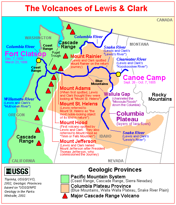
| On October 7, 1805, Lewis and Clark and the "Corps of Discovery" began their journey down the Clearwater River and into the volcanics of the Pacific Northwest. The Corps travelled from the Clearwater to the Snake and down the "Great Columbia", finally reaching the Pacific Ocean on November 15, 1805. Along the journey they encountered the lava flows of the Columbia Plateau, river channels carved by the great "Missoula Floods", and the awesome beauty of five Cascade Range volcanoes. |
| The Volcanoes of Lewis and Clark |
| To the Pacific - October 1805 |
|
Down the "Great Columbia" Snake/Columbia Confluence to Spring Gulch |
| The Corps of Discovery camped for two days (October 16 and 17, 1805) at the confluence of the Snake and Columbia Rivers at what is now known as Sacajawea State Park just outside Pasco on U.S. Route 12 heading towards Walla Walla. The original campsite is now under the waters of Lake Wallula, behind McNary Dam. |
|
|
 Sacajawea State Park:
Sacajawea State Park: The Corps of Discovery camped for two days (October 16 and 17, 1805) at the confluence of the Snake and Columbia Rivers at what is now known as Sacajawea State Park just outside Pasco on U.S. Route 12 heading towards Walla Walla. Sacajawea State Park is a 284-acre marine, day-use park at the confluence of the Snake and Columbia rivers. It features 9,100 feet of freshwater shoreline. The area is spread out with a big sky and excellent views of the two rivers as they flow together. The park's lands are sand dunes interspersed with wetland ponds. The park is on the plain of the great Lake Missoula floods, which swept through the area 12,000 years ago. The property was deeded to Washington State Parks in 1931. The park is named for Sacajawea, a Shoshoni Indian woman who traveled with the Lewis and Clark expedition. The original campsite is now under the waters of Lake Wallula, behind McNary Dam. -- Washington State Parks and Recreation Website, 2002 |
|
We were visited this morning by several canoes of
Indians, who joined those who were already with us, and
soon opened a numerous council.
......
We now procured from the principal chief and
one of the Cuimnapum nation a
sketch of the
Columbia
[Columbia River],
and the tribes of his nation living along its
banks and those of the
Tapteet
[Yakima River].
They drew it with a
piece of coal on a robe, and as
we afterwards transferred to paper,
it exhibited a valuable specimen of Indian
delineation.
Having completed the purposes of our stay, we now began to lay in our stores ...... The morning was cool and fair, and the wind from the southeast. |
| "... at 4 oClock we set out down the Great Columbia accompanied by our two old Chiefs, one young man wished to accompany us, but we had no room for more, & he could be of no service to us ..." [Clark, October 18, 1805] |
| "... Capt. Lewis had an observation at noon, which gave 46o 15 13.9 north latitude. At one we proceeded on down the Great Columbia, which is a very beautiful river. The course is something to the east of south for about 12 miles and then winds round to almost a west course ..." [Gass, October 18, 1805] |
| "... a clear pleasant morning. we delayed here until after 12 oClock to day Capt. Clark measured Columbia River and the Ki mo e nem Rivers and found the Columbia River to be 860 yards wide, and the ki moo enem R. to be 475 yards wide at the forks. Capt. Lewis Compleated his observations and found the Latitude to produce ... North ... about 2 oClock P.M. we Set out. two chiefs continued on with us ..." [Ordway, October 18, 1805] |
|
|


 Junction of the Columbia River and Snake River:
The Columbia River before Lewis and Clark: On May 12, 1792, the American Captain Robert Gray, became the first explorer to enter the Columbia River by crossing over the sandbar that blocked its mouth. Gray sailed about 20 miles up the estuary of the river, traded with the Indians for a few days, and then left after drawing a chart of the mouth of the river. He named the river the Columbia after his ship, and claimed it for the United States. British Captain George Vancouver obtained a copy of Gray's chart from the Spanish governor at Nootka Sound and sailed to the mouth of the Columbia River in October 1792. He was unable to get his flagship Discovery over the sandbar, but Lt. William Robert Broughton succeeded with his smaller ship, the Chatham. Broughton advanced nearly 100 miles to a site opposite present-day Portland, Oregon, which he named Point Vancouver. To the east he saw a majestic mountain peak which he named Mount Hood. -- University of Virginia Library Special Collections Website, 2002 
 Snake River:
The Snake River originates in Yellowstone National Park at 9,500 feet and winds through southern Idaho before turn0 feet and winds through southern Idaho before turning north to form the boundary between Idaho and Oregon. It finally joins the Columbia River near Pasco, Washington, at 340 feet in elevation, 1,036 miles from its source. How did it get its name? To identify themselves, Indians living along the river in southern Idaho used a hand sign that resembled the movement of a snake. Although it didn't mean "Snake", that name was given to this group of people, now known as Shoshone. The river flowing through the Snake Indian lands was given the tribal name. Lewis and Clark traveled through this area on their journey to find an inland waterway to the Pacific. Many miles upriver from Hells Gate State Park, the Snake River winds through Hells Canyon, one of the deepest gorges in North America. This wild and spectacular area is best visited by boat; there are no roads leading through the canyon. Old homesteads, long-forgotten prospector cabins, and Native American petroglyphs offer a fascinating human story in the midst of the spectacular scenery. -- U.S. National Park Service, Wild and Scenic Rivers Website, 2002, and Idaho State Parks and Recreation Website, 2002 |
| Soon after proceeding, We passed the island in the mouth of Lewis river [Snake River], and at eight miles reached a larger island, which extends three miles in length. On going down by this island there is another on the right, which commences about the middle of it, and continues for three and a half miles. While they continue parallel to each other, they occasion a rapid near the lower extremity of the first island, opposite to which on the second island are nine lodges built of mats, and intended for the accommodation of the fishermen, of whom we saw great numbers, and vast quantities of dried fish on their scaffolds. [These Islands are most likely Rabbit Island and Goat Island, now under the waters of Lake Wallula.] |
|
|
Islands at the Mouth:
|
| On reaching the lower point of the island, we landed to examine a bad rapid, and then undertook the passage which is very difficult, as the channel lies between two small islands, with two others still smaller near the left side of the river. Here are two Indian houses, the inhabitants of the river. Here are two Indian houses, the inhabitants of which were as usual drying fish. We passed the rapid without injury, and fourteen and a half miles from the mouth of Lewis's river [Snake River], came to an island near the right shore, on which were two other houses of Indians pursuing the customary occupation. [This entire east bank of the Columbia, from downstream the Snake River to the Walla River, is now a part of the McNary National Wildlife Refuge.] |
| "... we proceeded on down the great Calumbia River which is now verry wide about 3/4 of a mile in General the country in general Smooth plains for about 10 miles down then the barron hills make close to the River on each Side. passed Several Smooth Islands on which was large fishing Camps. large quantity of Sammon on their Scaffels. ..." [Ordway, October 18, 1805] |
|
|
 McNary National Wildlife Refuge:
McNary National Wildlife Refuge: The McNary National Wildlife Refuge spans the east bank of the Columbia from the Snake River to the Wallula Gap. The Refuge now has 7 Units: Strawberry Island, Burbank Slough (original McNary NWR), Peninsula, Two Rivers, Wallula, Stateline, and Juniper Canyon. Originally established at 3,600 acres, the Refuge now encompasses over 15,000 acres of backwater sloughs, seasonal wetlands, shrub-steppe uplands, irrigated farmlands, river islands, delta mudflats, and riparian areas. The Refuge also includes riverine wetlands and shoreline bays that serve as an important nursery for developing fall chinook salmon. The Refuge has trails, wildlife viewing, and an education center. and is located southeast of Pasco off U.S. Highway 12 just south of the Snake River. Refuge Visitor facilities are a quarter mile east of Highway 12 on Maple Street. -- Lewis and Clark Bicentennial in Oregon Website, 2002, and U.S. Fish & Wildlife Service Website, 2002 |
| One mile and a half beyond this place, is a mouth of a small brook [Walla Walla River]. under a high hill on the left. It seems to run during its whole course through the high country, which at this place begins, |
|
|


 Walla Walla River:
Walla Walla River: The Walla Walla River flows out of the Blue Mountains, originating at nearly 6,000 feet and flows through narrow, well-defined canyons. After it leaves the mountains it flows through broad valleys that drain low, rolling lands. The principle tributaries of the Walla Walla River include the Touchet River, Mill Creek, and the North and South Forks of the Walla Walla River. The Walla Walla River basin drains an area of 1,758 square miles. According to Coues (History of the Expedition of Lewis and Clark, page 969), walla means running water, and redupliction of a word diminutizes it, so Wallawalla is the small rapid river. Lewis and Clark use the name Wallow Wallow, with several variations. Old Fort Walla Walla (For Nez Perce), at the mouth of the Walla Walla River, in Washington, was established in 1818 by the North West Company, and was abandoned in 1855. The city of Walla Walla, 33 miles east, came into importance in 1860-61, amid placer gold mining activities. It was first settled in 1855. -- Columbia Basin Fish and Wildlife Authority Website, 2002, and McArthur, 1982, Oregon Geographic Names Geology of the Walla Walla River Basin: As the river winds its way through the Walla Walla watershed, it crosses two major physiologic provinces: the Blue Mountains and the valley lowland. The Blue Mountains dominate the topography of the basin with an average elevation of 5,000 feet along the subbasin boundary, the highest point being Table Mountain at 6,000 feet. The topography of the Blue Mountains province consists of flat-topped ridges and steep stair-stepped valley walls formed by thousands of feet of Miocene basalt flows that engulfed the folded, faulted, and uplifted granitic core of the mountains. As mountains were uplifted, streams and glaciers carved canyons through the basalt layers. The valley lowland extends from the center of the basin north to the divide between the Touchet and Snake Rivers and south to the Horse Heaven Hills. Land surface elevations of the lowland province range from 2,500 feet at the base of the Blue Mountains to less than 270 feet at the confluence with the Columbia River. The dominant bedrock across the region consists of a series of basalt flows known as the Columbia River basalt that are stacked like a layer cake across much of eastern Washington, eastern Oregon, and southern Idaho. Dating from 10 to 17 million years before present, the basalt is divided into formations, each an aggregation of individual flows sharing similar flow histories and geochemistry. The three major formations that occur in the Walla Walla subbasin are the Saddle Mountains, Wanapum, and Grande Ronde. The flow thickness can range from five feet to as much as 150 feet, and collectively is estimated to be hundreds to thousands of feet thick. The topography of the basin is directly related to the folding, faulting, and erosion of these formations, creating a regional structure that dips westward from the Blue Mountains, southward down the Touchet Slope (the area between the Walla Walla and Touchet Rivers), northward from Horse Heaven Ridge, and eastward from a dividing ridge in the lower Walla Walla valley. Fertile soils formed from Pleistocene silt and sand blanket the subbasin. During the Pleistocene ice ages, the region underwent severe change as the continental glaciers advanced and retreated to the north, and valley glaciers carved channels in the higher elevations. Massive floods swept through the Columbia basin periodically through the Quaternary era, bringing vast amounts of sediment into the region. Wind, intensified by the expanse of glacial ice, piled the sand and silt known as loess into dunes that spread across much of central and southeastern Washington. These dunes characterize the region known as the Palouse, and can be seen throughout the Walla Walla subbasin. The Touchet beds are another reflection of Pleistocene glaciation and climate. They represent cyclic slow water deposits laid down when massive floods resulting from the breaching of an ice dam located near Missoula, Montana scoured the area and backed up into the mouth of the Walla Walla River. -- Columbia Basin Fish and Wildlife Authority Website, 2002 |
| and rising to the height of two hundred feet form cliffs of rugged black rocks which project a considerable distance into the river [Wallula Gap]. |
| "... at 16 miles from the point the river passes into the range of high Countrey at which place the rocks project into the river from the high clifts which is on the Lard. Side about 2/3 of the way across and those of the Stard. Side about the Same distance, the Countrey rises here about 200 feet above The water and is bordered with black rugid rocks, at the Commencement of this high Countrey on Lard Side a Small riverlet falls in which appears to passed under the high Country in its whole cose ..." [Clark, October 18, 1805] |
|
|
 Wallula Gap:
Wallula Gap: Glacial-outburst waters that crossed the Channeled Scablands during the Spokane floods (Missoula Floods) were channeled through Wallula Gap. For several weeks, as much as 200 cubic miles of water per day were delivered to a gap that could discharge less than 40 cubic miles per day. Ponded water filled the Pasco Basin and the Yakima and Touchet valleys to form temporary Lake Lewis. -- U.S. National Park Service, National Natural Landmarks Program Website, 2002 Wallula Gap National Natural Landmark: Prominent Lava Flows seen from Wallula Gap vicinity: Horse Heaven Hills anticline sections show excellent exposures of the thick Frenchman Springs member overlain by the Umatilla Member of the Saddle Mountains Basalt -- the Roza and Priest Rapids Members are missing. A Martindale flow caps the highest visible point west of the river; it overlies imbricated Snake River gravel, compositionally similar to that at Lower Monumental Dam, showing that an ancestral Wallula Gap existed at least 8.5 million years ago. The Saddle Mountains Basalt formation is the youngest in the Columbia River Basalt Group. It is about 13.5 to 6 million years old and contains flows erupted sporadically during a period of waning volcanism, deformation, canyon cutting, and development of thick but local sedimentary deposits between flows. The Saddle Mountains Basalt has a volume of only about 700 cubic miles, less than one percent of the total volume of basalt, yet contains by far the greatest chemical and isotopic diversity of any formation in the group. -- Swanson and Wright, 1981 |
| On the left bank of the Columbia River, within the Wallula Gap, lies a basalt feature known as the "Two Sisters". |
|
|
Two Sisters:
Two Sisters: A natural Native American monument overlooks the Columbia River two miles southwest from Wallula Junction on Highway 730. The Two Sisters are actually two basalt pillars (Frenchman Springs) which were formed by the Missoula Floods about 15,000 years ago. The Two Sisters are from a single lava flow that stood up to the ravages of the floodwaters, which completely surrounded and submerged them. Apparently the basalt here is slightly harder and/or more resistant to erosion than the basalt around them. Cayuse legend has it that Coyote, an animal spirit, turned two beautiful sisters to stone in a rage of jealousy. There is a nice pullout from Highway 730 with a new sign by the U.S. Army Corps of Engineers that describes the legend and the surrounding area. -- Walla Walla Chamber of Commerce Website, 2002, Lewis and Clark Bicentennial in Oregon Website, 2002, U.S. Army Corps of Engineers Website, 2002, and Pacific Northwest National Laboratory Website, 2003 |
| At this place too we observed a mountain to the S. W. the form of which is conical, and its top covered with snow [Mount Hood]. |
| "... Saw a mountain bearing S. W. Conocal form Covered with Snow. ..." [Clark, October 18, 1805] |
| The conical mountain, which Clark does not identify from his maps, is Mount Hood. In this stretch of the river it is only occasionally visible. |
|
|


 Mount Hood:
|
| We followed the river as it entered these highlands, and at the distance of two miles reached three islands, one on each side of the river, and a third in the middle, on which were two houses, where the Indians were drying fish opposite a small rapid. Near these a fourth island begins, close to the right shore, where were nine lodges of Indians, all employed with their fish. As we passed they called to us to land, but as night was coming on, and there was no appearance of wood in the neighbourhood, we went on about a mile further, till observing a log that had drifted down the river, we landed near it on the left side, and formed our camp under a high hill [near Port Kelley and Spring Gulch Creek], after having made twenty miles today. |
| "... We went 21 miles and halted close below an Indian camp; where they have thirty canoes; and a great quantity of dried fish." [Gass, October 18, 1805] |
| "... we passed over Several rapids. no timber along the Shores. we Camped on the Lard Side at a fiew willows which we got to burn ..." [Ordway, October 18, 1805] |
|
|


 Port Kelly and Spring Gulch:
Port Kelley and Spring Gulch: Port Kelley is on the East side of the Columbia River, 16 miles above McNary Dam. Lewis and Clark's campsite of October 18, 1805 was located about 1 miles downstream from Port Kelley. Today the location of the campsite is under the waters of Lake Wallula, behind McNary Dam. -- NOAA, Office of Coast Survey Website, 2003, and Fort Walla Walla Museum Website, 2003 |
|
|
|
The Camp - October 18, 1805:
Lewis and Clark camped near Port Kelley, at Spring Gulch Creek, just south of the confluence of the Walla Walla River and the Columbia River. Port Kelley is on the East side of the Columbia River, 16 miles above McNary Dam. The campsite was located about 1 mile downstream from Port Kelley. Today the location of the campsite along with the islands the Corp passed, is under the waters of Lake Wallula, behind McNary Dam. |
Return to:
[Volcanoes and History Menu] ...
[Living With Volcanoes Menu] ...
