USGS/CVO Logo, click to link to National USGS Website
USGS/Cascades Volcano Observatory, Vancouver, Washington

The Volcanoes of Lewis and Clark

October 25 - 28, 1805

The Dalles -
"Long Narrows"

 
Home
-- The Volcanoes of Lewis and Clark

Map of the Journey
-- Volcanoes, Basalt Plateaus, Major Rivers, etc.

CALENDAR of the Journey
-- October 1805 to June 1806

Along the Journey
-- Pacific Northwest Maps - Columbia River, Volcanoes, Flood Basalts, Missoula Floods, Geology, etc.

The Corps of Discovery
-- The Journey of Lewis and Clark

About the Reference Materials
-- The Journals, Biddle/Allen, DeVoto, Gass, Moulton, Topo Maps, and others

USGS Lewis and Clark Links
-- Links to USGS Websites highlighting the Lewis and Clark Journey

Resources
Publications Referenced and Websites Visited

PREVIOUS

October 24
"Short Narrows"
October 25-28

The Dalles,
"Long Narrows"

Horsethief Butte, Horsethief Lake State Park, Five-Mile Rapids and the "Long Narrows", Big Eddy, The Dalles and The Dalles Dam, Mill Creek, Rock Fort, Mount Hood, Rocky Island and Crate's Point
CONTINUE

October 29
Entering the Columbia River Gorge, The Dalles to the Little White Salmon
 

On October 7, 1805, Lewis and Clark and the "Corps of Discovery" began their journey down the Clearwater River and into the volcanics of the Pacific Northwest. The Corps travelled from the Clearwater to the Snake and down the "Great Columbia", finally reaching the Pacific Ocean on November 15, 1805. Along the journey they encountered the lava flows of the Columbia Plateau, river channels carved by the great "Missoula Floods", and the awesome beauty of five Cascade Range volcanoes.


Map, Lewis and Clark in the Pacific Northwest
(Click map for brief summary about the area)


The Volcanoes of Lewis and Clark
To the Pacific - October 1805
The Dalles
"Long Narrows"

Friday, October 25, 1805

Lewis and Clark's camp of October 24, 1805, was on the Washington State side of the Columbia River, near the location of today's Horsethief Lake State Park. Interpretive signs at Horsethief Lake State Park.


Along the Journey - October 25, 1805
Horsethief Lake State Park:
Horsethief Lake State Park is a 338-acre camping park with 7,500 feet of freshwater shoreline on the Columbia River. Horsethief Butte dominates the skyline. It stands over the lake like an ancient castle. The lake itself is about 90 acres in size and is actually an impoundment of the Columbia River. The lake was flooded into existance by the reservoir created by The Dalles Dam. For centuries, the park was the site of a Native American village. The Lewis and Clark expedition camped at the village and described its wooden houses in one of their journals. The village was flooded by the waters of The Dalles Dam. Oral history states that the park received its name from workers in the U.S. Army Corps of Engineers who developed the site. The workers thought the terrain was similar to that of horsethief hideouts in popular 1950s Hollywood westerns. The abundance of horses kept on the premises by local Indians apparently gave the workers their inspiration. -- Washington State Parks and Recreation Website, 2002


Geology of Horsethief Butte and Vicinity:
Horsethief Butte and the surrounding Columbia River channel were carved out of basalt rock by floods following the last ice age. The basalt rock resulted from a series of lava flows which emerged from cracks in the earth's crust and blanketed the entire eastern Washington/Oregon region long before the coming of ice-age floods. When viewing the cliffs along the river, notice the stratigraphy highlighted by benches rising up the cliffs. Each of these benches, or layers, represents a different lava flow. Some lava flows were hundreds of feet thick in places. -- Washington State Parks and Recreation Website, 2002


We walked down with several of the Indians to view the part of the narrows [Five Mile Rapids - The Long Narrows] which they represented as most dangerous: we found it very difficult, but, as with our large canoes the portage was impracticable, we concluded on carrying our most valuable articles by land, and then hazarding the passage. We therefore returned to the village, and after sending some of the party with our best stores to make a portage, and fixed others on the rock to assist with ropes the canoes that might meet with any difficulty, we began the descent, in the presence of great numbers of Indians who had collected to witness this exploit.
"... Capt. Lewis and my Self walked down to See the place the Indians pointed out as the worst place in passing through the gut, which we found difficuelt of passing without great danger, but as the portage was impractiable with our large canoes, we concluded to Make a portage of our most valuable articles and run the canoes thro ..." [Clark, October 25, 1805]
The channel for three miles is worn through a hard rough black rock from fifty to one hundred yards wide. in which the water swells and boils in a tremendous manner.
"... this Chanel is through a hard rough black rock, from 50 to 100 yrads wide, swelling and boiling in a most tremendious maner; we passed through a deep bason to the Stard. Side of 1 mile below which rhe River narrows and divided by a rock ..." [Clark, October 25, 1805]


Along the Journey - October 25, 1805
Map, 1887, The Dalles vicinity, click to enlarge Map, 1858 Military recon map, The Dalles vicinity, click to enlarge Map, 1888, Five Mile Rapids, click to enlarge Map, 1934 USGS topo map upstream of The Dalles, click to enlarge Image, ca. 1914, Five Mile Rapids, click to enlarge Image, The Dalles, click to enlarge Image, ca.1910, The Dalles, click to enlarge Five Mile Rapids, The Long Narrows, or "The Dalles":
  1. 1887 Map (section of original), Columbia River at The Dalles. (Click to enlarge). Original Map: The Columbia River from Celilo to the mouth showing locations of the salmon fisheries, 1887. Scale ca. 1:375,000, Relief shown by hachures. U.S. Army Corps of Engineers, Engineer Office, G.P.O. 1888. University of Washington Archives #UW128. -- University of Washington Library Archives Website, 2002
  2. 1858 Military Recon Map (section of original), Columbia River and The Dalles Vicinity. (Click to enlarge). Map of military reconnaissance from Fort Dalles, Oregon, via Fort Wallah-Wallah, to Fort Taylor, Washington Territory, 1858. Shows approximate location of military road constructed 1859 to 1862. From the report and maps of Captain John Mullan, United States Army, G.P.O., 1863. University of Washington Archives #UW85. -- University of Washington Library Archives Website, 2002
  3. 1888 Map (section of original), Columbia River at Three Mile Rapids, the Big Eddy, and Five Mile Rapids, 1880. (Click to enlarge). Original Map: Map of Columbia River from The Dalles to Celilo, Oregon, 1888. Scale 1:30,000. Relief shown by contours. Shows a section of the Columbia River, including fall and rapids, water gauges, and "basaltic" region. Original map is reduced from sheet 1 and 2, survey of 1879-1880, G.P.O. 1889. University of Washington Archives #UW66. -- University of Washington Library Archives Website, 2002
  4. 1934 Map (section of original), from The Dalles 1:125,000 topographic quadrangle. (Click to enlarge). The Columbia River upsteam of The Dalles, Oregon (the Washington side is not depicted on this map), including Three Mile Rapids, Big Eddy, and Five Mile Rapids. Original map surveyed in 1929-30, contour interval of 50 feet. -- University of Washington Library Collections Website, 2002
  5. 1914, Columbia River at Five Mile Rapids. (Click to enlarge). Water Resources Department Records, Photographs and Negatives, 93A-011. -- Oregon State Archives Website, 2002
  6. ca.1879-1909, "The Dalles" (Click to enlarge). A scene in the region served by the Oregon Railway & Navigation Company between 1879-1909. Oregon State Archives Photograph, Photograph Date: 1879-1909, From: Salem Public Library Collection. -- Oregon State Archives Website, 2002
  7. ca. 1910, Columbia River area Indians fishing with spears from platforms at The Dalles, Oregon, ca.1910. (Click to enlarge). University of Washington Archives Photograph #NA746, General Indian Collection no.564. Photograph Date: ca.1910. From: University of Washington Libraries, Seattle, Washington -- University of Washington Libraries and the Library of Congress, American Memories Website, 2002

Long Narrows:
The "Long Narrows" was also known as "Five Mile Rapids", "The Dalles", and "The Great Dalles". During the steamboad era on the Columbia River, rapids in this vicinity were called names representing their distance east from the boat landing at the Dalles. The Five Mile Rapids area was under consideration as a dam site about 1914. Decades later The Dalles Dam was constructed downstream. -- Washington State Historical Society Website, 2002, Washington State Lewis and Clark Heritage Website, 2002, and Oregon State Archives Website, 2002


Archaeology at Five Mile Rapids:
Excavations at Five Mile Rapids, a few miles east of The Dalles, show humans have occupied this ideal salmon fishing site for more than 10,000 years. -- U.S. Forest Service Website, 2002, The Columbia River Gorge


The three first canoes escaped very well; the fourth, however, had nearly filled with water; the fifth passed through with only a small quantity of water over her. At half a mile we had got through the worst part, and having reloaded our canoes went on very well for two and a half miles, except that one of the boats was nearly lost by running against a rock. At the end of this channel of three miles, in which the Indians inform us they catch as many salmon as they wish, we reached a deep basin or bend of the river towards the right [Big Eddy], near the entrance of which are two rocks.


Along the Journey - October 25, 1805
Map, 1888, Five Mile Rapids, click to enlarge Map, 1934 USGS topo map upstream of The Dalles, click to enlarge Big Eddy:
  1. 1888 Map (section of original), Columbia River at Three Mile Rapids, the Big Eddy, and Five Mile Rapids, 1880. (Click to enlarge). Original Map: Map of Columbia River from The Dalles to Celilo, Oregon, 1888. Scale 1:30,000. Relief shown by contours. Shows a section of the Columbia River, including fall and rapids, water gauges, and "basaltic" region. Original map is reduced from sheet 1 and 2, survey of 1879-1880, G.P.O. 1889. University of Washington Archives #UW66. -- University of Washington Library Archives Website, 2002
  2. 1934 Map (section of original), from The Dalles 1:125,000 topographic quadrangle. (Click to enlarge). The Columbia River upsteam of The Dalles, Oregon (the Washington side is not depicted on this map), including Three Mile Rapids, Big Eddy, and Five Mile Rapids. Original map surveyed in 1929-30, contour interval of 50 feet. -- University of Washington Library Collections Website, 2002

Big Eddy:
Big Eddy was at the western end of the obstructions in the Columbia River at The Dalles. It was at this point that travelers and freight began the portage around these obstructions. The name "Big Eddy" probably came into use at the time of gold discoveries in eastern Oregon just after 1860. -- McArthur, 1982, Oregon Geographic Names


We crossed the basin [Big Eddy], which has a quiet and gentle current, and at the distance of a mile from its commencement, and a little below where the river resumes its channel, reached a rock which divides it. At this place we met our old chiefs, who, when we began the portage, had walked down to a village below to smoke a pipe of friendship on the renewal of peace. ...... On leaving this rock the river is gentle, but strewed with a great number of rocks for a few miles [Three-Mile Rapids]


Along the Journey - October 25, 1805
Map, 1888, Five Mile Rapids, click to enlarge Map, 1934 USGS topo map upstream of The Dalles, click to enlarge Map, 1934 USGS topo map of The Dalles Mill Creek area, click to enlarge Three-Mile Rapids:
  1. 1888 Map (section of original), Columbia River at Three Mile Rapids, the Big Eddy, and Five Mile Rapids, 1880. (Click to enlarge). Original Map: Map of Columbia River from The Dalles to Celilo, Oregon, 1888. Scale 1:30,000. Relief shown by contours. Shows a section of the Columbia River, including fall and rapids, water gauges, and "basaltic" region. Original map is reduced from sheet 1 and 2, survey of 1879-1880, G.P.O. 1889. University of Washington Archives #UW66. -- University of Washington Library Archives Website, 2002
  2. 1934 Map (section of original), from The Dalles 1:125,000 topographic quadrangle. (Click to enlarge). The Columbia River upsteam of The Dalles, Oregon (the Washington side is not depicted on this map), including Three Mile Rapids, Big Eddy, and Five Mile Rapids. Original map surveyed in 1929-30, contour interval of 50 feet. -- University of Washington Library Collections Website, 2002
  3. 1934 Map, The Dalles (section of original), from The Dalles 1:125,000 topographic quadrangle. (Click to enlarge). Original map surveyed in 1929-30, contour interval of 50 feet. The Washington side of the river is not depicted on the map. -- University of Washington Library Collections Website, 2002


Once called "Three-Mile Rapids", today this location is the vicinity of The Dalles Dam and The Dalles Bridge connecting the states of Washington and Oregon.


Along the Journey - October 25, 1805
NASA Image, 1997, Columbia River from The Dalles to Rock Creek, click to enlarge Image, 1958, The Dalles Vicinity, Oregon, click to enlarge Image, The Dalles Dam, Oregon, click to enlarge Image, The Dalles Dam, Oregon, click to enlarge The Dalles Dam:
  1. 1997, Aerial view Columbia River from The Dalles to Rock Creek (Click to enlarge). View from space - northeast looking photograph of Columbia River, The Dalles Dam, John Day Dam, Miller Island, Maryhill area, Deschutes River, John Day River, and Rock Creek, 1997. The Columbia River flows upper right (east) to lower left (west). NASA Earth from Space #STS085-734-085. -- NASA Earth from Space Website, 2002
  2. 1958, All the rapids of the Columbia River were inundated in March 1957 when The Dalles Dam was completed, forming Lake Celilo. (Click to enlarge). Oregon State Archives Photograph #7246(Ben Maxwell). Photograph Date: September 15, 1958. Photographer: Ben Maxwell. From: Salem Public Library Collection. -- Oregon State Archives Website, 2002
  3. Aerial view, The Dalles Dam, Oregon. (Click to enlarge). In this image, Oregon is on the left with the city of The Dalles (upper central) and Interstate-84 prominently running through the view. Washington State is on the right. -- U.S. Army Corps of Engineer Website, 2003
  4. Image, The Dalles Dam, taken from the Washington side looking back towards Oregon and The Dalles city. (Click to enlarge). -- Environmental Protection Agency Website, 2003

The Dalles Dam:
The Dalles Dam is located 192 miles upstream from the mouth of the Columbia River, two miles east of the city of The Dalles, Oregon. The dam extends 1.5 miles from the Oregon shore to the navigation lock on the Washington shore. Because the boundary between the two states follows the old river channel, The Dalles Dam is almost entirely in the state of Washington. The project consists of a navigation lock, spillway, powerhouse and fish passage facilities. Various recreational facilities are provided along Lake Celilo, the 24-mile-long impoundment behind the dam. -- U.S. Corps of Engineers Website, 2002


when it becomes a beautiful still stream about half a mile wide [location of today's city of The Dalles].


Along the Journey - October 25, 1805
Map, 1855, Columbia River, Walla Walla to Vancouver, click to enlarge Map, 1858 Military recon map, The Dalles vicinity, click to enlarge Map, 1858 Military recon map, The Dalles vicinity, click to enlarge Map, 1887, The Dalles vicinity, click to enlarge Map, 1888, Five Mile Rapids, click to enlarge Map, 1934 USGS topo map upstream of The Dalles, click to enlarge NASA Image, 1997, Columbia River from The Dalles to Rock Creek, click to enlarge Image, ca.1879-1909, The Dalles, click to enlarge Image, ca.1910, The Dalles, click to enlarge Stereo Image, 1867, The Dalles, click to enlarge Engraving, 1853, The Dalles and Mount Hood, click to enlarge Engraving detail, 1884, The Dalles and Mount Hood, with Mill Creek, click to enlarge The Dalles, Oregon:
  1. 1855 Map, Columbia River, including The Dalles (Dalles) (section of original). (Click to enlarge). Original Map: "Map of Oregon and Washington Territories: showing the proposed Northern Railroad route to the Pacific Ocean, by John Disturnell, 1855. University of Washington Archives #UW155. -- University of Washington Library Collections Website, 2002
  2. 1858 Military Recon Map (section of original), Columbia River and The Dalles Vicinity. (Click to enlarge). Map of military reconnaissance from Fort Dalles, Oregon, via Fort Wallah-Wallah, to Fort Taylor, Washington Territory, 1858. Shows approximate location of military road constructed 1859 to 1862. From the report and maps of Captain John Mullan, United States Army, G.P.O., 1863. University of Washington Archives #UW85. -- University of Washington Library Archives Website, 2002
  3. 1858 Military Recon Map, close-in view (section of original), Columbia River and upstream The Dalles. (Click to enlarge). Map of military reconnaissance from Fort Dalles, Oregon, via Fort Wallah-Wallah, to Fort Taylor, Washington Territory, 1858. Shows approximate location of military road constructed 1859 to 1862. From the report and maps of Captain John Mullan, United States Army, G.P.O., 1863. University of Washington Archives #UW85. -- University of Washington Library Archives Website, 2002
  4. 1887 Map (section of original), Columbia River at The Dalles. (Click to enlarge). Original Map: The Columbia River from Celilo to the mouth showing locations of the salmon fisheries, 1887. Scale ca. 1:375,000, Relief shown by hachures. U.S. Army Corps of Engineers, Engineer Office, G.P.O. 1888. University of Washington Archives #UW128. -- University of Washington Library Archives Website, 2002
  5. 1888 Map (section of original), Columbia River at Three Mile Rapids, the Big Eddy, and Five Mile Rapids, 1880. (Click to enlarge). Original Map: Map of Columbia River from The Dalles to Celilo, Oregon, 1888. Scale 1:30,000. Relief shown by contours. Shows a section of the Columbia River, including fall and rapids, water gauges, and "basaltic" region. Original map is reduced from sheet 1 and 2, survey of 1879-1880, G.P.O. 1889. University of Washington Archives #UW66. -- University of Washington Library Archives Website, 2002
  6. 1934 Map (section of original), from The Dalles 1:125,000 topographic quadrangle. (Click to enlarge). The Columbia River at The Dalles, Oregon (the Washington side is not depicted on this map), including Three Mile Rapids, Big Eddy, and Five Mile Rapids. Original map surveyed in 1929-30, contour interval of 50 feet. -- University of Washington Library Collections Website, 2002
  7. 1997, NASA Image, Columbia River from The Dalles to Rock Creek (Click to enlarge). View from space - northeast looking photograph of Columbia River, The Dalles Dam, John Day Dam, Miller Island, Maryhill area, Deschutes River, John Day River, and Rock Creek, 1997. The Columbia River flows upper right (east) to lower left (west). NASA Earth from Space #STS085-734-085. -- NASA Earth from Space Website, 2002
  8. ca.1879-1909, A scene in the region served by the Oregon Railway & Navigation Company between 1879-1909. (Click to enlarge). Oregon State Archives Photograph, Photograph Date: 1879-1909, From: Salem Public Library Collection. -- Oregon State Archives Website, 2002
  9. ca.1910, Columbia River area Indians fishing with spears from platforms at The Dalles, Oregon, ca.1910. (Click to enlarge). University of Washington Archives Photograph #NA746, General Indian Collection no.564. Photograph Date: ca.1910. From: University of Washington Libraries, Seattle, Washington -- University of Washington Libraries and the Library of Congress, American Memories Website, 2002
  10. 1867, Stereo view, The Dalles. (Click to enlarge). View from upstream. Caption on image: Dalles City, Columbia River, view from the East. Photographer: Carleton E. Watkins. Photo Date: 1867. University of Washington Sterocard Collection #STE048, Stereocard Collection No. 58. -- University of Washington Libraries Collection Website, 2003
  11. 1853 Engraving, Columbia River area indian camp at The Dalles, Oregon, with Mount Hood in the background. (Click to enlarge). Engraving by John M. Stanley, 1853. From the U.S. War Department's Reports of explorations and surveys to ascertain the most practicable and econmical route for a railroad from the Mississippi River to the Pacific Ocean, 1860, v.12, pt.1, pl.43. University of Washington Libraries Collection, #NA4170. -- University of Washington Libraries Website, 2002
  12. 1884, Detail from engraving of The Dalles, Oregon with Mount Hood on the skyline and the Columbia River and the mouth of Mill Creek in the foreground. (Click to enlarge). Created by H. Wellge. Published 1884, J.J. Stoner, Madison, Wisconsin. Panoramic view of the city of The Dalles, Oregon, county seat of Wasco County, 1884. Original lithograph shows The Dalles, Mount Hood, the Columbia River, and the mouth of Mill Creek. Reference #LC Panoramic Maps #727. -- Library of Congress American Memories Website, 2002

The Dalles:
The name "The Dalles", is derived from the French word dalle, means flagstone, and was applied to the narrows of the Columbia River above the present city of The Dalles. Undoubtedly the peculiar basalt formation suggested flagstone to the French-Canadian employees of the fur companies. This area was the center of trade for tribes from the Plains to the Pacific. The Dalles Dam has visitor center and guided tour train. -- Oregon State Archives Website, 2002, and Lewis & Clark Bicentennial in Oregon Website, 2002


At five miles from the large bend we came to the mouth of a creek [Mill Creek] twenty yards wide, heading in the range of mountains [Cascade Mountains] which run S. S. W. and S. W. for a long distance, and discharging a considerable quantity of water: it is called by the Indians Quenett [Mill Creek].


Along the Journey - October 25, 1805
Map, 1858 Military recon map, The Dalles vicinity, click to enlarge Map, 1887, The Dalles vicinity, click to enlarge Map, 1934 USGS topo map of The Dalles Mill Creek area, click to enlarge Engraving detail, 1884, The Dalles and Mount Hood, with Mill Creek, click to enlarge Engraving detail, 1884, The Dalles and Mill Creek, click to enlarge Mill Creek:
  1. 1858 Military Recon Map (section of original), Columbia River and The Dalles Vicinity. (Click to enlarge). Map of military reconnaissance from Fort Dalles, Oregon, via Fort Wallah-Wallah, to Fort Taylor, Washington Territory, 1858. Shows approximate location of military road constructed 1859 to 1862. From the report and maps of Captain John Mullan, United States Army, G.P.O., 1863. University of Washington Archives #UW85. -- University of Washington Library Archives Website, 2002
  2. 1887 Map (section of original), Columbia River at The Dalles, including Mill Creek. (Click to enlarge). Original Map: The Columbia River from Celilo to the mouth showing locations of the salmon fisheries, 1887. Scale ca. 1:375,000, Relief shown by hachures. U.S. Army Corps of Engineers, Engineer Office, G.P.O. 1888. University of Washington Archives #UW128. -- University of Washington Library Archives Website, 2002
  3. 1934 Map (section of original), from The Dalles 1:125,000 topographic quadrangle. (Click to enlarge). Original map surveyed in 1929-30, contour interval of 50 feet. The Washington side of the river is not depicted on the map. -- University of Washington Library Collections Website, 2002
  4. 1884, Detail from engraving of The Dalles, Oregon with Mount Hood on the skyline and the Columbia River and the mouth of Mill Creek in the foreground. (Click to enlarge). Created by H. Wellge. Published 1884, J.J. Stoner, Madison, Wisconsin. Panoramic view of the city of The Dalles, Oregon, county seat of Wasco County, 1884. Original lithograph shows The Dalles, Mount Hood, the Columbia River, and the mouth of Mill Creek. Reference #LC Panoramic Maps #727. -- Library of Congress American Memories Website, 2002
  5. 1884, Closer-in detail from engraving of The Dalles, Oregon, and the mouth of Mill Creek. (Click to enlarge). Created by H. Wellge. Published 1884, J.J. Stoner, Madison, Wisconsin. Panoramic view of the city of The Dalles, Oregon, county seat of Wasco County, 1884. Original lithograph shows The Dalles, Mount Hood, the Columbia River, and the mouth of Mill Creek. Reference #LC Panoramic Maps #727. -- Library of Congress American Memories Website, 2002

Mill Creek:
Lewis and Clark acquired the name "Que-neet Creek," also spelled "Que-nett," meaning "salmon trout," from the local Indians and applied it to a small stream on the southern shore of the Columbia. Seeking a defensive position for an encampment, they ascended the stream and found a natural rock formation for their security. Mill Creek, the present place name, derived from the establishment of a sawmill on the stream during the military occupation at Fort Dalles, Oregon Territory. The fort was an important military post during the Indian wars era. -- Washington State Historical Society Website, 2002


We halted below it under a high point of rocks on the left; and as it was necessary to make some celestial observations, we formed a camp on the top of these rocks [Rock Fort Camp, The Dalles, Oregon]. This situation is perfectly well calculated for defence in case the Indians should incline to attack us, for the rocks form a sort of natural fortification with the aid of the river [Columbia River] and creek [Mill Creek], and is convenient to hunt along the foot of the mountains to the west and southwest, where there are several species of timber which form fine coverts for game.
"... we proceeded on down the water fine, rocks in every derection for a fiew miles when the river widens and becoms a butifull jentle Stream of about half a mile wide, Great numbers of the Sea orter about those narrows and both below and above. we came too, under a high point of rocks on the Lard. Side below a creek of 20 yards wide and much water, as it was necessary to make Some Selestial observations we formed our camp on the top of a high point of rocks which forms a kind of fortification in the Point between the river & creek, with a boat guard ..." [Clark, October 25, 1805]


Along the Journey - October 25, 1805
The Camp - October 25 through October 27, 1805:
Lewis and Clark set up camp at "Rock Fort" during both their journey to the Pacific and their journey home (October 25 through October 27, 1805, and April 15 through April 17, 1806). The fort-like basalt outcropping lies just downstream from the mouth of Mill Creek at present-day The Dalles, Oregon, on a wedge-shaped parcel bordered by the Columbia River, Bargeway Road, and Bridge and Garrison Streets. A riverfront trail leads to Rock Fort where interpretive signage marks the campsite. -- U.S. National Park Service Website, Lewis and Clark Expedition, 2003


From this rock, the pinnacle of the round mountain covered with snow, which we had seen a short distance below the forks of the Columbia, and which we had called the Falls or Timm mountain [Mount Hood], is south 43° west, and about thirty-seven miles distant.


"... passed great numbers of rocks, good water and Came to at a high point of rocks below the mouth of a Creek which falls in on the Lard Side and head up towards the high Snow mountain to the S W. this Creek is 20 yards wide and has Some beaver sign at its mouth river about 1/2 mile wide and Crouded with Sea otters ..." [Clark, October 25, 1805]
"... This little Creek heads in the range of mountains which run S S W & N W for a long distance on which is Scattering pine white Oake &c.; The Pinical of the round toped mountain which we Saw a Short distance below the forks of this river is S. 43o W. of us and abt 37 miles, it is at this time toped with Snow we called this the 'falls mountain' or 'Timm' mountain ..." [Clark, October 25, 1805]
"... we cn Still See the round high mountain Some distance a head yet. we Camped below the mouth of a creek on a point of rocks on the Lard. Side. the country timbered back a little from the River ..." [Ordway, October 25, 1805]


Along the Journey - October 25, 1805
Engraving, 1853, The Dalles, Oregon, with Mount Hood, click to enlarge Engraving detail, 1884, The Dalles and Mount Hood, with Mill Creek, click to enlarge Penny Postcard, ca.1915, Mount Hood from The Dalles, click to enlarge Mount Hood and The Dalles, Oregon:
  1. 1853 Engraving, Columbia River area indian camp at The Dalles, Oregon, with Mount Hood in the background. (Click to enlarge). Engraving by John M. Stanley, 1853. From the U.S. War Department's Reports of explorations and surveys to ascertain the most practicable and econmical route for a railroad from the Mississippi River to the Pacific Ocean, 1860, v.12, pt.1, pl.43. University of Washington Libraries Collection, #NA4170. -- University of Washington Libraries Website, 2002
  2. 1884, Closer-in detail from engraving of The Dalles, Oregon, and Mount Hood. (Click to enlarge). Created by H. Wellge. Published 1884, J.J. Stoner, Madison, Wisconsin. Panoramic view of the city of The Dalles, Oregon, county seat of Wasco County, 1884. Original lithograph shows The Dalles, Mount Hood, the Columbia River, and the mouth of Mill Creek. Reference #LC Panoramic Maps #727. -- Library of Congress American Memories Website, 2002
  3. ca.1915, Penny Postcard, Mount Hood from near The Dalles. (Click to enlarge). "Mount Hood as seen from bank of the Columbia River near The Dalles, Ore.", A.M. Prentiss Photo. #447, Lipschuetz of Katz, Portland, Oregon. -- L.Topinka private collection, 2003, used with permission.

Map, the Volcanoes of Lewis and Clark, click to enlarge Map, 1855, Columbia River, Vancouver to the Pacific, click to enlarge Map, 1911 USGS topo map of Mount Hood, click to enlarge NASA Image, 1994, Columbia River Gorge, Mount Hood, Mount Adams, and Mount St. Helens, click to enlarge NASA Image, 1997, Columbia River, Mount Hood, and Mount Adams, click to enlarge Engraving, 1848, Mount Hood and Oregon City, Oregon, click to enlarge Engraving, 1853, The Dalles, Oregon, with Mount Hood, click to enlarge Engraving detail, 1884, The Dalles and Mount Hood, with Mill Creek, click to enlarge Engraving detail, 1879, Portland Oregon and Mount Hood, click to enlarge Engraving detail, 1890, Portland Oregon and Mount Hood, click to enlarge Penny Postcard, ca.1915, Mount Hood from The Dalles, click to enlarge Penny Postcard, ca1930, Mount Hood as seen from White Salmon, Washington, click to enlarge Penny Postcard, ca.1930, Portland, Oregon and Mount Hood, click to enlarge Image, Mount Hood from Timberline, click to enlarge Mount Hood:
  1. Map, "Volcano Siting", October 25, 1805, a "round mountain covered with snow ... the Falls or Timm mountain" (Mount Hood) (#4)
  2. 1855 Map, Columbia River from Vancouver to the Pacific, including Mount Hood (although not named) (section of original). (Click to enlarge). Original Map: "Map of Oregon and Washington Territories: showing the proposed Northern Railroad route to the Pacific Ocean, by John Disturnell, 1855. University of Washington Archives #UW155. -- University of Washington Library Collections Website, 2002
  3. 1911 Map of Mount Hood (section of original), from Mount Hood and Vicinity 1:125,000 topographic quadrangle. (Click to enlarge). Original map surveyed in 1907 and 1909-1911, contour interval of 100 feet. -- University of Washington Library Collections Website, 2002
  4. 1994, NASA Image, Columbia River Gorge (section of original). (Click to enlarge). View from space - Columbia River and the Columbia River Gorge, west-northwest-looking, low-oblique photograph, September 1994. The Columbia River is running from the bottom (east) to the top (west). The Cascade Range is the dark color through the middle of the image, with Mount Hood on the Oregon side of the Columbia and Mount Adams and Mount St. Helens on the Washington side of the Columbia. NASA Earth from Space #STS064-112-092. -- NASA Earth from Space Website, 2002
  5. 1997, NASA Image, Columbia River looking northeast, with Mount Adams and Mount Hood (Click to enlarge). View from space - Columbia River, Willamette Valley, Columbia Plateau, Mount Adams, and Mount Hood. In this northeast-looking photograph the Columbia River flows right (east) to left (west). NASA Earth from Space #STS085-734-085. -- NASA Earth from Space Website, 2002
  6. 1848, Etching of Mount Hood and American Village (Oregon City). (Click to enlarge). Etching by Henry James Warre, 1848. Oregon City was first settled in 1829. Dr. John McLoughlin is generally credited as the town's founding father, having contructed an early lumber mill there. Oregon City was an early capitol of the territory, until the territorial capitol was finally moved to Salem in 1851. In his book, the artist (Henry Warre) notes that a rival city had sprung up further down the Willamette during the summer of 1845 - this would become Portland, Oregon. Washington State University Archives Collection #WSU554. -- Washington State University Libray Archives Website, 2002
  7. 1853 Engraving, Columbia River area indian camp at The Dalles, Oregon, with Mount Hood in the background. (Click to enlarge). Engraving by John M. Stanley, 1853. From the U.S. War Department's Reports of explorations and surveys to ascertain the most practicable and econmical route for a railroad from the Mississippi River to the Pacific Ocean, 1860, v.12, pt.1, pl.43. University of Washington Libraries Collection, #NA4170. -- University of Washington Libraries Website, 2002
  8. 1884, Closer-in detail from engraving of The Dalles, Oregon, and Mount Hood. (Click to enlarge). Created by H. Wellge. Published 1884, J.J. Stoner, Madison, Wisconsin. Panoramic view of the city of The Dalles, Oregon, county seat of Wasco County, 1884. Original lithograph shows The Dalles, Mount Hood, the Columbia River, and the mouth of Mill Creek. Reference #LC Panoramic Maps #727. -- Library of Congress American Memories Website, 2002
  9. 1879, Detail of engraving of Portland, Oregon and Mount Hood. (Click to enlarge). Created by E.S. Glover. Published 1879, San Francisco. "Bird's-eye-veiw, looking east to the Cascade Mountains. Original lithograph shows Mount Rainier, Mount St. Helens, Mount Adams, and Mount Hood, and also the Columbia River and the Willamette River. Reference #LC Panoramic Maps #722. -- Library of Congress American Memories Website, 2002
  10. 1890, Detail from engraving of Portland, Oregon with Mount Hood. (Click to enlarge). Created by Clohessy & Strengele. Published 1890, San Francisco. "Bird's-eye-view", Portland, Oregon, 1890. Original lithograph shows Mount Rainier (???), Mount St. Helens, Mount Adams, and Mount Hood, and also the Columbia River and the Willamette River. Reference #75694939. -- Library of Congress American Memories Website, 2002
  11. ca.1915, Penny Postcard, Mount Hood from near The Dalles. (Click to enlarge). "Mount Hood as seend from bank of the Columbia River near The Dalles, Ore.", A.M. Prentiss Photo. #447, Lipschuetz of Katz, Portland, Oregon. -- L.Topinka private collection, 2003, used with permission.
  12. ca.1930, Penny Postcard, Mount Hood as seen from White Salmon, Washington. (Click to enlarge). "Mount Hood and Interstate Bridge to Columbia River Highway from Evergreen Highway, White Salmon, Wash. to Hood River, Oregon." #826. -- L.Topinka private collection, 2003, used with permission
  13. ca.1930, Penny Postcard. Portland, Oregon and Mount Hood. (Click to enlarge). Angelus Commercial studio, Portland, Oregon. -- L.Topinka private collection, 2003, used with permission.
  14. Mount Hood, as seen from Timberline. (Click to enlarge). USGS photo by Lyn Topinka. -- USGS Cascades Volcano Observatory Photo Archives, 2002
Snow-clad Mount Hood dominates the Cascade skyline from the Portland metropolitan area to the wheat fields of Wasco and Sherman Counties. The mountain contributes valuable water, scenic, and recreational resources that help sustain the agricultural and tourist segments of the economies of surrounding cities and counties. Mount Hood is also one of the major volcanoes of the Cascade Range, having erupted repeatedly for hundreds of thousands of years, most recently during two episodes in the past 1,500 years. The last episode ended shortly before the arrival of Lewis and Clark in 1805, and consisted of growth and collapse of a lava dome that sent numerous pyroclastic flows down the south and west flanks. Crater Rock is the remnant of that dome. Mount Hood is 11,245 feet high, is the fourth highest peak in the Cascades, and the highest in Oregon. It was named after a British admiral and first described in 1792 by William Broughton, a member of an expedition under command of Captain George Vancouver. -- Scott, et.al., 1997, Gardner, et.al., 2000, and Swanson, et.al., 1989


The face of the country on both sides of the river above and below the falls is steep, rugged, and rocky, with a very small proportion of herbage, and no timber, except a few bushes: the hills, however, to the west, have some scattered pine, white oak and other kinds of trees. All the timber used by the people at the upper falls is rafted down the Towahnahiooks [Deschutes River]; and those who live at the head of the narrows we have just passed, bring their wood in the same way from this creek to the lower part of the narrows, from which it is carried three miles by land to their habitations. ......
"... The face of the Countrey, on both Side of the river above and about the falls, is Steep ruged and rockey open and contain but a Small preportion of erbage, no timber a fiew bushes excepted ..." [Clark, October 25, 1805]


Saturday, October 26, 1805

The morning was fine: we sent six men to hunt and to collect rosin to pitch the canoes, which, by being frequently hauled over rocks, have become very leaky. ...... We were occupied with the observations necessary to determine our longitude ...... The fleas, with whom we had contracted an intimacy at the falls, are so unwilling to leave us, that the men are obliged to throw off all their clothes, in order to relieve themselves from their persecution.


Along the Journey - October 26, 1805
The Camp - October 25 through October 27, 1805:
Lewis and Clark set up camp at "Rock Fort" during both their journey to the Pacific and their journey home (October 25 through October 27, 1805, and April 15 through April 17, 1806). The fort-like basalt outcropping lies just downstream from the mouth of Mill Creek at present-day The Dalles, Oregon, on a wedge-shaped parcel bordered by the Columbia River, Bargeway Road, and Bridge and Garrison Streets. A riverfront trail leads to Rock Fort where interpretive signage marks the campsite. -- U.S. National Park Service Website, Lewis and Clark Expedition, 2003


"... the Country to the Lard is broken Country thinly timbered with pine and white oake, a mountain which I must call 'Timm' or 'falls' Mountain rises verry high and bears to the S W the Course it has bore Sinc we first Saw it ..." [Clark, October 26, 1805]


Along the Journey - October 26, 1805
Mount Hood:
[See October 25, 1805 entry]


Sunday, October 27, 1805

The wind was high from the westward during the night and this morning, but the weather begin fair we continued our celestial observations. ......


Along the Journey - October 27, 1805
The Camp - October 25 through October 27, 1805:
Lewis and Clark set up camp at "Rock Fort" during both their journey to the Pacific and their journey home (October 25 through October 27, 1805, and April 15 through April 17, 1806). The fort-like basalt outcropping lies just downstream from the mouth of Mill Creek at present-day The Dalles, Oregon, on a wedge-shaped parcel bordered by the Columbia River, Bargeway Road, and Bridge and Garrison Streets. A riverfront trail leads to Rock Fort where interpretive signage marks the campsite. -- U.S. National Park Service Website, Lewis and Clark Expedition, 2003


"... The Creek at which we are Encamped is Called by the natives - 'Que-nett' - ... The pinical of Falls mountain bears S 43o W. about 35 miles ..." [Clark, October 27, 1805]


Along the Journey - October 27, 1805
Mount Hood:
[See October 25, 1805 entry]


Monday, October 28, 1805

The morning was again cool and windy. Having dried our goods, we were about setting out, when three canoes came from above to visit us, and at the same time two others from below arrived for the same purpose. ...... This interview detained us till nine o'clock, when we proceeded down the river, which is now bordered with cliffs of loose dark coloured rocks about ninety feet high with a thin covering of pine and other small trees.


Along the Journey - October 28, 1805
High Cliffs:


At the distance of four miles we reached a small village of eight houses under some high rocks on the right, with a small creek [Chenoweth Creek ???] on the opposite side of the river. We landed and found the houses similar to those we had seen at the great narrows ......
"... an Indian village of hte 'Chee-luck-it-te-quar' nation of 8 houses ... passed the mouth of a Small Creek ..." [Clark, October 28, 1805]
The wind however rose so high, that we were obliged after going one mile to land on the left side opposite to a rocky island [vicinity of today's Rocky Island], and pass the day there. We formed our camp in a niche above a point of high rocks [upstream of Crates Point], and as it was the only safe harbour we could find, submitted to the inconvenience of lying on the sand, exposed to the wind and rain during all the evening. ......


Along the Journey - October 28, 1805
Map, 1934 USGS topo map of Crate's Point area, click to enlarge 
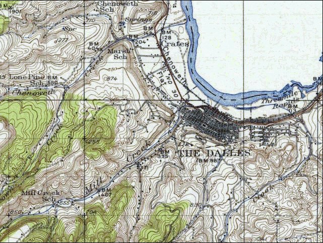
Rocky Island and Crates Point:
  1. 1934 Map (section of original), from The Dalles 1:125,000 topographic quadrangle. (Click to enlarge). Map section showing Rowena, Crates Point, and Crates. Rocky Island is not named and not depicted as an Island on this map. It is depicted as a spit of land half way between Crates Point and Crates. Original map surveyed in 1929-30, contour interval of 50 feet. The Washington side of the river is not depicted on the map. -- University of Washington Library Collections Website, 2002

Rocky Island:
Lewis and Clark's "rocky island" was on the Washington side of the river. Today, "Rocky Island" is the name given to an island on the Oregon side of the Columbia.


Crate's Point:
Crate's Point is a conspicuous promontory west of The Dalles, where the Columbia River changes course from north to west. Crate's Point is part of the east portal of the Columbia River Gorge. Crate's Point and Crates (a nearby railway station) were named for Edward Crate, a French-Canadian who came to Oregon as an employee of the Hudson's Bay Company in 1838. In 1851, Edward Crate filed a claim on a settlement near the river under the slope of the bluff, which he selected because it was adapted to landing boats. -- McArthur, 1982, Oregon Geographic Names


"... the wind rose and we were obliged to lie by about 1 mile below on the Lard. Side North 1 mile to a rock Island on the Stard. Side. ... rained all the evenig & blew hard from the West encamped on the Lard Side opsd. an Rock in a verry Bad place ..." [Clark, October 28, 1805]
"... A cool windey morning we loaded our Canoes and Set out at 9 oClock, a.m. ... we proceeded on river inclosed on each Side in high Clifts of about 90 feet of loose dark coloured rocks at four miles we landed at a village of 8 houses on the Stard. Side under Some rugid rocks ... the wind rose and we were obliged to lie by all day at 1 mile below on the Lard. Side ... wind blew hard accompanied with rain all the evening, our Situation not a verry good one for an encampment, but Such as it is we are obliged to put up with, the harbor is a Safe one, we encamped on the Sand wet and disagreeable ..." [Clark, October 28, 1805]


Along the Journey - October 28, 1805
The Camp - October 28, 1805:
Oregon side of the Columbia River, near Rocky Island, Oregon, upstream of Crate's Point.


Return to:
[Volcanoes and History Menu] ...
[Living With Volcanoes Menu] ...


ButtonBar

URL for CVO HomePage is: <http://vulcan.wr.usgs.gov/home.html>
URL for this page is: <http://vulcan.wr.usgs.gov/LivingWith/Historical/LewisClark/volcanoes_lewis_clark_october_25_1805.html>
If you have questions or comments please contact: <GS-CVO-WEB@usgs.gov>
03/22/04, Lyn Topinka