A Ponderosa Pine Natural Area Reveals Its Secrets

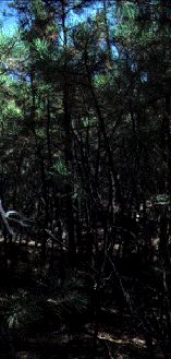
Monument Canyon Research Natural Area preserves an unlogged 259-hectare stand of old-growth ponderosa pine in the Jemez Mountains of New Mexico. This preserve, established in 1932, is the oldest research natural area in the state. This two-tiered forest displays an old-growth density of 100 stems per hectare (Muldavin et al. 1995), with an understory thicket of stagnant saplings and poles that raises the total stand density to an average of 5,954 stems per hectare, with concentrations as high as 21,617 stems per hectare (Fig. 1).
Courtesy C. D. Allen, USGS
The old overstory trees in the research area are declining and dying, possibly from altered nutrient and water availabilities and competition with the dense understory saplings (Sackett et al. 1994). A thick layer of ponderosa pine needles blankets the forest floor, and herbaceous plant diversity is low. Although 34 herbaceous species have been found on the 259-hectare site (Deichmann 1980), as many as 60 might be expected in more open stands that have regularly experienced fire and which lack the dense sapling layer. Further, those herbs that do occur are usually found only as isolated individuals across the landscape.
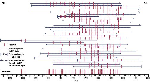
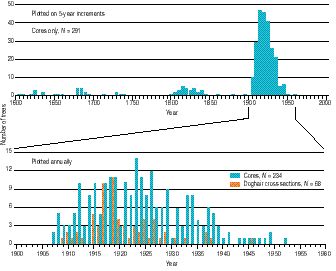
Fire scars show that surface fires burned through this forest about every 6 years for at least 300 years until 1892, when the last significant fire occurred (Fig. 2). Understory saplings that have been dated reveal that tree establishment greatly increased in the early 1900's (Muldavin et al. 1995; Fig. 3) after grass competition was reduced because of livestock grazing and after the fires that once inhibited pine regeneration were suppressed. As a result, a highly unnatural stand structure has developed, with the doghair thickets representing extreme density conditions, although similar conditions are found in many southwestern ponderosa pine stands (Covington and Moore 1994).

Analogous stand structures and high fuel loads prevailed in the nearby area burned by the 1977 La Mesa fire (Foxx and Potter 1984), when an intense crown fire converted 4,000 hectares of dense ponderosa pine forest into largely treeless grasslands. It is clear that fire is a keystone process in ponderosa pine forests--without it the whole ecosystem changes markedly. From this perspective the admonition emblazoned on the Monument Canyon Research Natural Area boundary sign acquires ironic overtones: "This area must be preserved in a natural state as near as possible."

Fig. 3. Ponderosa pine recruitment dates from Monument Canyon Research Natural Area (Muldavin et al. 1995). Dates are estimated from increment cores taken from living trees over 10 cm diameter at breast height and from cross sections taken at root crown from poles in doghair thickets. Because increment cores were taken near ground level but often did not intersect the pith, dates from cores are considered less accurate than dates from cross sections.
A number of small archaeological sites from ancestral Pueblo people are found within this research natural area; these sites are typified by a two-room field house dated to between 1330 and 1630. This house was probably used while the people tended adjoining farm plots. The ponderosa pine thicket that shrouds these sites today would render even small-plot farming impossible without wholesale forest clearance. Fire suppression is the primary reason for the profound transformation this forest has experienced in the past century.
U.S. Geological Survey
Biological Resources Division
Midcontinent Ecological Science Center
Jemez Mountains Field Station
Bandelier National Monument
Los Alamos, New Mexico 87544
References