Gage height, feet
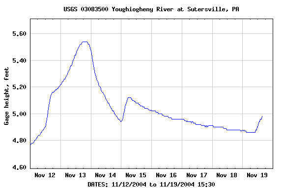
| Most recent value: 4.98 11-19-2004 15:30 | |
|
|
| Download a presentation-quality graph | Parameter Code 00065; DD 04 |
PROVISIONAL DATA SUBJECT TO REVISION |
||
| STATION.--03083500 YOUGHIOGHENY RIVER AT SUTERSVILLE, PA LOCATION.--Lat 40`14'24", long 79`48'24", Allegheny County, Hydrologic Unit 05020006, on left bank 500 ft upstream from highway bridge at Sutersville, 2.1 mi downstream from Sewickley Creek, and at mile 15.2. DRAINAGE AREA.--1,715 mi2. PERIOD OF RECORD.--October 1920 to current year. Monthly discharge only for some periods, published in WSP 1305. GAGE.--Water-stage recorder. Datum of gage is 733.36 ft above sea level. Prior to June 1, 1939, nonrecording gage at site 500 ft downstream at same datum. REMARKS.--Flow regulated since 1925 by Deep Creek Reservoir, since 1943 by Youghiogheny River Lake 58 mi upstream, and by several smaller reservoirs above station. U.S. Army Corps of Engineers satellite telemeter at station. FLOOD STAGE.--NOAA, National Weather Service river forecast station flood stage provided to USGS April 1999 is 20 feet. COOPERATION.--Funding for the operation of this station is provided by the U.S. Army Corps of Engineers, the Pennsylvania Department of Environmental Protection, and the U.S. Geological Survey. |
||
Gage height, feet |
|||||||
|
|||||||
Discharge, cubic feet per second |
||||||||||||||||||||||
|
||||||||||||||||||||||
|
||||||||||||||||||||||
| Questions about data | Water Webserver Team | Top |
| Feedback on this website | NWISWeb Support Team | Explanation of terms |
